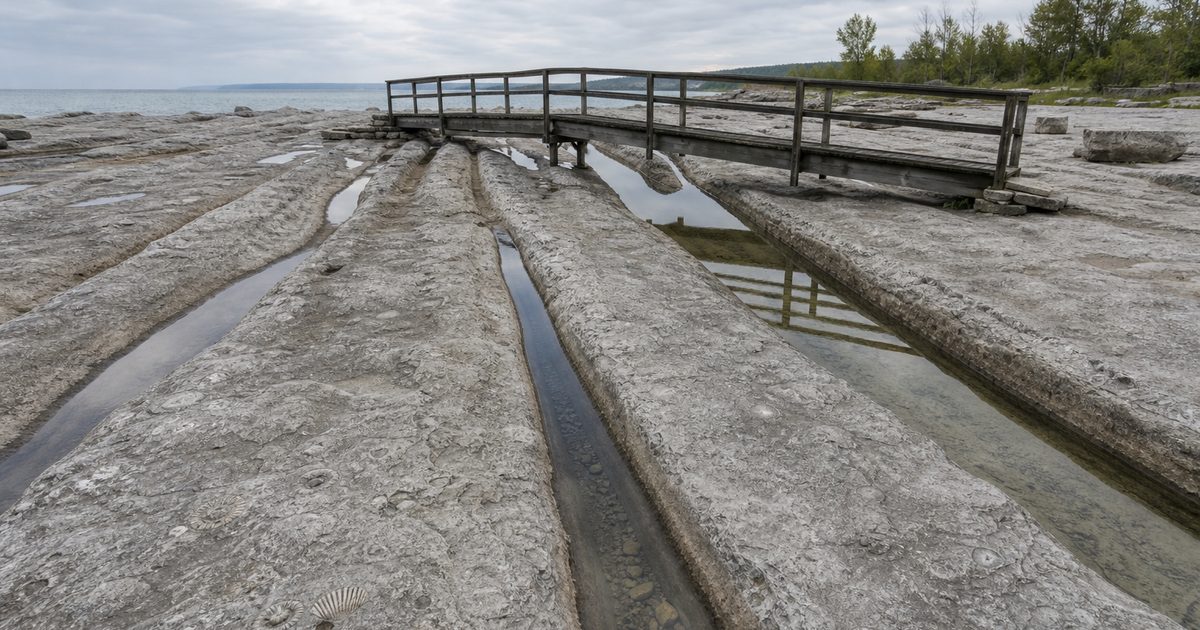
A channel on the north side of Kelleys Island cuts as much as 4.6 meters into solid limestone. Its sides curve and narrow; smaller grooves run within the larger hollow. Across the exposed rock, the channels extend for roughly 131 meters. Quarry workers removed enormous quantities of limestone here, but they did not carve these shapes.
The cutting happened beneath an ice sheet.
Around 18,000 years ago, during the last major glaciation, ice covered this part of what is now Lake Erie. Estimates place its thickness over the island at roughly 1.6 kilometers. Beneath that weight, moving ice, abrasive sediment and pressurized water reshaped the bedrock. Exactly how they produced the deepest channels remains a geological question.
The limestone itself tells a much older story. It formed in a Devonian sea roughly 390 million years ago, and marine fossils remain visible in the surface the glacier eroded. At the Glacial Grooves Geological Preserve, an ancient seabed and the work of an ice sheet occupy the same few meters of exposed stone.
The sea inside the stone
A fossil in the wall of a glacial channel can be easy to overlook. The eye follows the larger curves first, tracing the excavation along the rock. Then a shell or coral interrupts the surface, evidence that the material being worn away already contained a history.
Most of Kelleys Island rests on Columbus Limestone, a formation dating to the Middle Devonian. At that time, this part of North America lay south of the Equator beneath a shallow sea. Sediment accumulated on the seabed, incorporating the remains of marine organisms. Over geological time, those deposits became limestone.
The formation contains brachiopods, corals, crinoids and mollusks, among other fossils. Brachiopods were shelled animals; crinoids were relatives of sea stars whose jointed stems could resemble little stacks of discs. Their remains belong to a marine community far older than the freshwater lake surrounding the island.
Calling this rock simply “ancient” conceals the scale of the interval. Hundreds of millions of years separate its formation from the glacial erosion visible on its surface. The ice encountered limestone that had already hardened, fractured and undergone a long history of exposure and burial.
That distinction matters when looking into the grooves. The fossils do not date the channels. They date the rock through which the channels pass.
The stone also has a physical structure that influenced what happened to it. Bedding divides the limestone into layers, while joints cut across it. Those weaknesses gave erosion opportunities to work unevenly rather than wearing down a uniform block.
Before the glacier reached the ridge
Kelleys Island lies about 6.4 kilometers north of Marblehead, Ohio. The water separating them makes the island appear self-contained, but its bedrock belongs to a larger regional structure.
It forms part of a ridge extending southward through Ohio from the vicinity of Pelee Island in Canada. That ridge lies along the eastern flank of the Cincinnati Anticline, a broad geological uplift.
Streams had already eroded the older landscape before the later ice sheets advanced. They cut into the bedrock and helped divide the ridge into separate hills. Glaciers subsequently modified that inherited terrain.
The distinction prevents a misleading picture of ice arriving on a flat limestone plain and creating the entire landscape at once. The glaciers encountered relief: higher ground, lower passages, fractured rock and pre-existing drainage routes. Their movement altered those features, sometimes removing material and sometimes leaving deposits behind.
Repeated glaciations during the Quaternary Period, which began about 2.6 million years ago, helped shape the region. The surviving grooves belong to the much later part of that history, associated with the last major ice advance.
They preserve a particular episode of erosion, not the whole making of Lake Erie.
A channel beneath a mile of ice
The principal surviving exposure measures approximately 131 meters long and 10.7 meters wide. Its deepest channels reach about 4.6 meters below the surrounding surface. In imperial measurements, that is roughly 430 feet long, 35 feet wide and 15 feet deep.
Depth is the measurement that most changes the view. A scratch suggests a stone dragged across a floor. Here, the rock has been excavated deeply enough to create a channel a person could stand inside and still remain below its rim.
Smaller furrows complicate the larger forms. The surface records erosion operating at different scales, rather than a single clean sweep. Its broadly southwestward alignment helps geologists reconstruct movement beneath the former ice cover.
During the Late Wisconsin glaciation, the Laurentide Ice Sheet spread across the region. The estimated mile of ice above Kelleys Island gives some sense of the load, though ice thickness varied through time and across the landscape.
Pressure alone, however, does not explain the carving. Ice can slide over rock without cutting a deep groove. To excavate limestone, the glacial system needed tools: sediment capable of abrading the bed, and movement capable of carrying it.
The channels make that work visible. Identifying which tools did most of it is less straightforward.
Ice, stones or water?
The glacial origin of the grooves is well established. The detailed mechanism of their formation remains debated.
The familiar explanation involves stones embedded in the base of moving ice. Gravel and larger fragments scraped across the limestone under pressure, wearing away the bedrock. In that account, the glacier transported the abrasive material and supplied the force that pressed it against the surface.
This process helps explain glacial scratches and polished rock in many landscapes. Applying it to the deepest channels raises further questions about how erosion became concentrated along particular paths.
Another interpretation gives a larger role to meltwater flowing beneath the glacier. Under a thick ice sheet, water can move under pressure rather than behaving like an open stream. Laden with sand and other sediment, such flows can abrade bedrock and enlarge channels.
That possibility changes the scene one imagines. Instead of a boulder slowly gouging its way through limestone, picture sediment-rich water confined beneath ice, repeatedly working along a passage.
These explanations need not describe entirely separate worlds. Moving ice, rock fragments and meltwater could operate within the same subglacial environment. The question concerns their relative importance in producing the forms preserved here.
It would therefore be too neat to assign every hollow to a single stone or every curve to a particular current. The exposed rock supplies evidence of erosion; geologists interpret the processes responsible. Keeping those two things distinct makes the site more interesting, not less.
What the quarries removed
The limestone’s usefulness almost cost the island this record.
During the nineteenth and twentieth centuries, extensive quarrying removed bedrock for industrial use. Quarry operations exposed glacially worked surfaces, but they also destroyed them. Once workers broke up and carried away a section of limestone, its grooves disappeared with it.
The surviving exposure is therefore a remnant of a larger geological record. Its boundaries reflect decisions about extraction and preservation as well as the reach of glacial erosion.
In 1892, the Kelley Island Lime & Transport Company set aside a section of quarry land containing grooves. That action protected the basis of the landmark visible today. The company’s name uses “Kelley,” although the island’s name is “Kelleys.”
Preservation did not immediately produce the open view visitors now encounter. Later excavation cleared material covering the surviving channels, and work in the 1970s helped reveal the exposure for public viewing.
That history requires a careful distinction. People uncovered the grooves; they did not create their shape. The channels are natural features presented within a landscape that quarrying substantially altered.
The result carries an uncomfortable irony. Industrial activity helped bring the rock’s geological detail to attention while consuming other examples of it. The protected section cannot show everything that once existed, and there is no way to recover the surfaces already crushed or removed.
Looking without walking on the evidence
Walkways, steps and a footbridge allow visitors to examine the preserved channels without crossing the carved surface. The Glacial Grooves site holds National Natural Landmark status.
The viewing infrastructure also affects how the geology becomes legible. Looking along the exposure reveals its length and alignment. Looking down into it makes the depth apparent. Closer attention brings out the subsidiary furrows, bedding and fossils that broad photographs can flatten.
No single viewpoint explains the whole formation. A long view can make the channels resemble tracks; a closer one reveals how irregular their surfaces are.
The barriers protect more than an impressive shape. Fossil-bearing limestone is vulnerable to repeated foot traffic, collecting and damage. Remaining on designated routes leaves the evidence in place for other visitors and for future study.
At the edge of the exposure, the timescales become unusually specific. A fossil marks life in a Devonian sea. The channel cutting through it records erosion beneath a Pleistocene ice sheet. The cleared rock and surrounding quarry ground show where people chose to extract, excavate and preserve. Each left a different kind of mark.
FAQ
How were the Kelleys Island glacial grooves formed?
They formed through erosion beneath the Laurentide Ice Sheet. Geologists debate the relative roles of stones carried by moving ice and sediment-laden meltwater flowing under pressure.
How big are the glacial grooves?
The main preserved exposure is approximately 131 meters long and 10.7 meters wide. Its deepest channels reach about 4.6 meters.
How old are the grooves and the limestone?
The grooves are associated with the last major glaciation, around 18,000 years ago. The Columbus Limestone is much older, dating to the Middle Devonian, roughly 390 million years ago.
Can you see fossils in the grooves?
Yes. Marine fossils occur in the exposed limestone, including within the grooved surface. They belong to the ancient seabed, not to the period when glaciers covered the island.
Can you walk through the glacial grooves?
Visitors view the formation using designated walkways, steps and a footbridge. Stay off the carved rock and leave fossils in place to protect the exposure.