In April 2007, the floor of Dolomieu Crater dropped by about 350 metres. Lava was pouring out of Piton de la Fournaise farther down its flank, while the summit above collapsed inward. The eruption added rock to Réunion’s southeastern slopes and left a vast hollow at the top.
That pairing runs through the island’s geological history. Lava builds; gravity and water dismantle. The steep walls of the interior belong to the same story as the black flows along the coast, although the events that shaped them occurred on very different timescales.
Réunion lies in the Indian Ocean, east of Madagascar, in the Mascarene Islands. Across roughly 2,512 square kilometres, two volcanic massifs dominate the terrain. Piton des Neiges rises above deeply excavated valleys in the northwest. Piton de la Fournaise remains active in the southeast. Between them, they reveal how an oceanic volcano grows, weakens and changes long after its eruptions cease.
A mountain begins below the sea
The visible island is only the upper part of a much larger volcanic construction. Before any rock broke the ocean’s surface, repeated eruptions had to build a mountain from the seabed.
Réunion’s origins lie in a long-lived mantle hotspot: a region where hot material rises within the Earth and supplies magma to the crust. As tectonic plates move over such a source, volcanic activity can leave a trail of islands and submerged mountains.
Geologists link the Réunion hotspot to the immense eruptions that formed India’s Deccan Traps around 66 million years ago. This connection does not mean that Réunion itself is that old. It places the island near the younger end of a much longer volcanic history, traced through rocks scattered across the Indian Ocean.
The island’s own construction began several million years ago. Estimates of its age vary according to whether they refer to the submerged volcanic foundation, the oldest known rocks or emergence above sea level. Its appearance as dry land is commonly placed at approximately two million years ago.
The distinction matters. A coastline marks the point at which a growing volcano meets the sea, not the beginning of its existence.
Two massifs, unequal histories
Piton des Neiges forms most of Réunion’s northwestern mass. Its summit reaches 3,069 metres, the highest point in the Mascarene Islands. Despite its name, which means “snow peak,” it carries no permanent snow cover.
The volcano has been inactive for many thousands of years. Rain, rivers and slope failures have since cut deeply into its flanks, exposing an interior once buried beneath younger rock.
Piton de la Fournaise occupies the southeast. Its development began more than 500,000 years ago, and frequent eruptions continue to alter its surface. Much of that activity produces fluid basaltic lava, sometimes accompanied by fountains of incandescent material along eruptive fissures.
The two massifs are shield volcanoes, built largely through the accumulation of lava flows. Their broad underlying forms differ from the steep, relatively symmetrical cones often used to illustrate volcanoes. On Réunion, however, collapse and erosion have so thoroughly modified parts of those shields that their original outlines can be difficult to recognise.
The contrast is not a simple division between a dead mountain and a living one. The older massif still changes as slopes fail and streams deepen their channels. The younger volcano also loses ground through collapse, even as fresh lava enlarges it.
The hollows around Piton des Neiges
Mafate, Salazie and Cilaos open around the older summit as three enormous, steep-walled basins. These are Réunion’s cirques.
The word can mislead readers familiar with mountain landscapes shaped by ice. Here it describes the amphitheatre-like form of the terrain; these hollows are not glacial cirques. Nor are they three surviving craters around the summit.
Their development involved a complicated interaction of structural weakness, large slope failures and prolonged erosion. The relative importance and sequence of those processes differ across the massif. Describing the cirques simply as collapsed craters misses the scale of the later excavation.
Water has been an essential agent. Heavy rainfall feeds streams that cut into volcanic rock and carry loosened material downhill. Fractured rock and layers with different resistance to erosion help determine where valleys deepen and walls retreat. Occasional major failures can transform a slope much faster than the steady work of a river.
The resulting cliffs are known locally as remparts. Some expose stacks of volcanic material, making the mountain’s internal construction visible in cross-section. Their abrupt faces also show how much rock has disappeared.
Piton des Neiges still rises above these hollows. Its height is impressive, but the empty space around it is equally revealing. To understand the massif, it helps to consider the volume that is missing as well as the summit that remains.
Inside the Enclos Fouqué
On the active volcano, the Enclos Fouqué forms a broad, horseshoe-shaped depression around the summit cone. High remparts enclose much of it, while its eastern side opens towards the ocean through the Grandes Pentes and the coastal area known as the Grand Brûlé.
This arrangement helps explain why many eruptions remain within a relatively well-defined sector. Lava commonly spreads across the enclosure or travels down its eastern slopes. Some flows reach the coast; others stop well short of it. Eruptions can also occur outside the enclosure, so its boundary is not an absolute limit on volcanic hazards.
Two named craters occupy the summit: the smaller Bory and the larger Dolomieu. The latter changed dramatically during the 2007 eruption.
As magma drained from the volcano’s shallow plumbing system, the summit lost support. The crater floor subsided in a series of collapses, ultimately leaving a depression about 350 metres deep. The event connected processes that can seem unrelated when viewed separately: lava escaping downslope and ground failing high above it.
“Effusive” is the term used for eruptions dominated by lava outpouring rather than explosive fragmentation. It describes eruptive behaviour, not a guarantee of safety. Ground cracking, unstable crater margins, volcanic gases and moving lava remain serious hazards.
The wider history of the enclosure is less straightforward than its clear outline might suggest. Geologists have debated how caldera subsidence and large flank movements contributed to this part of the volcano. Similar questions surround older depressions near the Plaine des Sables. A sharply defined landform does not necessarily have a single, settled explanation.
The exposed ground of the Plaine des Sables
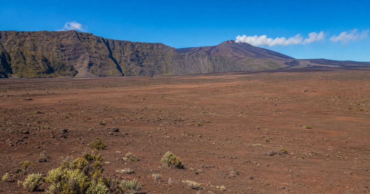
Beyond a steep descent on the approach to the active summit, the Plaine des Sables spreads across a high basin. Loose volcanic material gives much of its surface a reddish-brown colour. Vegetation is sparse, leaving the ground unusually exposed.
It offers a useful contrast with the deeply vegetated slopes elsewhere on Réunion. Where plants and soil obscure the underlying rock, geological structures can be difficult to read. Here, changes in colour, texture and relief remain visible across a broad area.
The plain belongs to an older part of the active massif’s development. It should not be mistaken for a surface created by the latest eruption, or treated as an extension of the present summit crater.
That distinction is easy to lose in a landscape where bare ground looks fresh. Volcanic scenery compresses different ages into a single view: an old enclosing cliff, younger deposits on the basin floor, and a still-active cone beyond. Appearance alone cannot supply the chronology.
Where the coastline gains ground
Along the southeastern coast, Route Nationale 2 crosses successive lava flows through the Grand Brûlé. The road’s interruptions and rebuilt sections reflect an awkward fact of infrastructure here: its route traverses ground that the volcano still uses.
When lava reaches the Indian Ocean, it cools rapidly at the surface while molten material may continue moving beneath a solidifying crust. Some eruptions extend the shoreline, creating new ground where there was water.
That new land is not necessarily stable. Waves attack it, cracks develop, and portions can collapse. Contact between lava and seawater also produces hazardous plumes containing steam, acidic gases and fine particles.
The black coastal rock therefore records more than the end of a lava flow. It marks a contested boundary between volcanic construction and marine erosion. Even after an eruption stops, the shape of the new shore continues to change.
Flows of different ages also weather differently. Fresh surfaces may remain dark and sparsely colonised, while older ones gradually acquire soil and vegetation. The contrast can help distinguish separate episodes, though colour and plant cover alone cannot establish a reliable date.
Protecting an unfinished landscape
In 2010, UNESCO inscribed the “Pitons, cirques and remparts of Reunion Island” on the World Heritage List. The designation recognises the island’s dramatic relief and the ecological importance of its varied terrain. It does not cover the whole island.
Much of the protected interior lies within Réunion National Park, whose core covers roughly two-fifths of the island. Here, conserving geological features also means protecting the habitats that have developed across different elevations, slopes and volcanic substrates.
Protection does not make the terrain static or permanently accessible. The Piton de la Fournaise volcano observatory monitors seismic activity, ground deformation and other signs of unrest. Authorities can close the Enclos Fouqué and surrounding areas when conditions warrant, including before an eruption begins.
An apparently quiet crater may still contain unstable ground or hazardous gases. Access depends on official decisions, not simply on whether lava is visible. At the edge of Dolomieu, the depth opened in 2007 remains a particularly stark reason to respect that distinction.
FAQ
How was Réunion Island formed?
Réunion grew through repeated volcanic eruptions above a mantle hotspot. Lava first built a mountain beneath the ocean before the island emerged above sea level.
What are Réunion’s two main volcanoes?
Piton des Neiges is the older, long-inactive massif in the northwest. Piton de la Fournaise, in the southeast, remains highly active and frequently produces basaltic lava flows.
How did the cirques of Mafate, Salazie and Cilaos form?
Large slope failures, structural processes and prolonged river erosion shaped the three basins around Piton des Neiges. They are neither glacial cirques nor simply intact volcanic craters.
What happened at Dolomieu Crater in 2007?
During a major eruption, magma withdrawal accompanied a series of summit collapses. The crater floor dropped by about 350 metres as lava escaped farther down the volcano.
Can you visit Piton de la Fournaise during an eruption?
Access depends on official restrictions. Authorities may close the Enclos Fouqué and nearby areas before or during unrest. Check current prefectural and national park notices before approaching.