A river leaves Lake Ontario and immediately loses its single course. It slips around ledges, narrows into channels, widens again, and in the space of about 80 kilometers breaks around 1,864 islands. Some are broad enough for farms and roads. Others are little more than a rock shelf and a wind-bent tree. The Thousand Islands can look improvised at first glance. In fact, few landscapes are easier to read once you know where to look.
This archipelago on the St. Lawrence River, between southeastern Ontario and northern New York, was not assembled piece by piece. It emerged from one underlying structure, then from ice, then from water. Much later, an international boundary cut through the same channels and gave the place a second, human geometry. The result is a region where geology and politics overlap so closely that one often explains the other.
Stone older than the river
The bedrock beneath the Thousand Islands belongs largely to the Grenville Province of the Canadian Shield. Here, that shield reaches southward across the river as the Frontenac Arch, also called the Frontenac Axis, linking the shield in Ontario with the Adirondack Mountains in New York State.
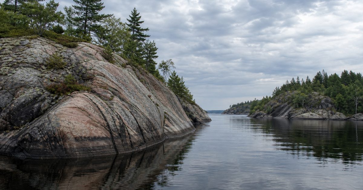
That link matters. It explains why so many shorelines here rise in bare, rounded rock instead of soft sediment. Much of the archipelago rests on granite and gneiss formed roughly 1.1 to 1.3 billion years ago. These are the deep roots of an ancient mountain belt, exposed after immense spans of uplift and erosion wore the higher ground away.
In places, younger Potsdam Sandstone appears along the flanks of the arch. It dates to about 500 million years ago. But the visual character of the islands comes mostly from the older shield rocks: hard ledges, smooth outcrops, and shorelines that seem cut directly from the earth’s basement.
The Frontenac Arch is more than a geological connection. It is also a corridor. Species moving between larger northern and southern habitats use this ridge and its islands as a chain of passage. Long before anyone drew a border here, the stone itself made this stretch of river a link rather than a barrier.
How ice made an archipelago
Old rock alone does not produce islands. The Thousand Islands took their present form during the last glaciation, when the Laurentide Ice Sheet covered this region.
Ice on that scale does not sit still. It grinds, plucks, and smooths. As it moved across the Frontenac Arch, it sculpted the bedrock into a pattern of rounded highs and lower hollows. Geologists often describe this as a knob-and-hollow landscape. The phrase is plain, but it fits. The islands are the knobs. The channels are the hollows, later filled by water.
When the glaciers retreated, the St. Lawrence occupied those lower spaces. That is the crucial sequence. The river did not build the islands in the way a coast might build sandbars. It flooded an already uneven rock surface. What remains above water are the higher parts of a drowned ridge.
Seen from above, the logic becomes obvious. The Thousand Islands do not form a tidy chain. They look fractured because the underlying terrain is fractured. They vary so sharply in size because the bedrock highs vary. A broad island and a tiny wooded rock belong to the same process.
That process has not entirely stopped. The land still responds, slowly, to the disappearance of the ice sheet through isostatic rebound. The change is too gradual to notice in daily life, but it belongs to the same long story of pressure, release, and adjustment.
Why there are 1,864 islands, not 1,000
The famous name undersells the count. There are 1,864 islands in the archipelago.
That number depends on a local rule repeated so often it has become part of the region’s folklore. To qualify as an island, a piece of land must stay above water year-round, measure at least one square foot, and support at least one living tree. Some versions of the rule say two trees, but the one-tree definition is the version most commonly cited.
The point is not just quaintness. The rule reflects the extreme intricacy of the landscape. In the Thousand Islands, the difference between island, shoal, and exposed rock can be very small. The count needs a threshold because the terrain keeps testing it.
At the large end is Wolfe Island, about 124 square kilometers. At the small end are scraps such as Just Room Enough Island, where the line between habitable land and geological joke becomes very thin. The range makes sense once the place is understood as flooded bedrock rather than a conventional island chain. This is not a set of separate objects scattered across a river. It is one broken surface, partly submerged.
Before the border, a lived water landscape
The Thousand Islands are the traditional territory of Haudenosaunee and Anishinaabe Peoples, including the Algonquins of Ontario. Human presence in the wider area reaches back thousands of years, with archaeological evidence often placed in the range of roughly 9,000 to 11,000 years before the present.
Later Indigenous use of the islands was seasonal, practical, and culturally meaningful. Iroquoian peoples, especially the Onondaga, used them as summer camping and fishing grounds. A name associated with the islands, Manitouana, is often translated as “Garden of the Great Spirit.” It should not be read as a romantic label for untouched nature. It refers instead to a place embedded in movement, subsistence, and memory.
European settlement after the American Revolution altered that geography sharply. Around the late eighteenth century, colonial landholding and military concerns began to reorganize the river. Seasonal Indigenous use did not vanish in a single moment, but older patterns were disrupted as the archipelago was folded into imperial and settler systems.
That history remains present. In and around Gananoque, for example, disputes over waterfront land and burial grounds show that questions of stewardship and belonging are not historical footnotes. They are active matters. Any account of the Thousand Islands that treats the region as scenery alone misses part of what shaped it.
A border threaded through water
The Canada-US border did not create the Thousand Islands, but it changed their meaning. Instead of one connected freshwater passage, the archipelago became a divided one. The line winds through channels and between islands with little regard for the shape of the land itself.
On a map, the effect can seem almost playful. In practice, it has long been serious. This stretch of the St. Lawrence was strategically important during the War of 1812. Names such as Navy, Admiralty, and Lake Fleet islands preserve traces of that military history.
The channels mattered because geology had already made them useful. Narrow passages, sheltered routes, and commanding points of rock became assets once rival states faced one another across the same water. The political geography followed the physical one, then hardened it.
That border is still unusually tangible. The Thousand Islands International Bridge, opened in 1938, links New York State and Ontario across the river and several islands. It gives concrete form to a line that otherwise slips through water and around stone. In winter, when conditions allow ice crossings elsewhere in the region, the idea of an international boundary can feel stranger still: a legal fact laid over a frozen river.
The archipelago has also produced one of those border stories that survives because it sounds too good to lose. A common claim says Zavikon Island is split by the international boundary and connected to a neighboring island by the world’s shortest international bridge. In fact, Zavikon Island lies entirely in Canadian waters. The tale endures because it suits the place. Here, people expect the border to do improbable things.
One ridge, several identities
What gives the Thousand Islands their coherence is not scenery but overlap. The Frontenac Arch provided the resistant stone. Glaciation carved that stone into highs and lows. The St. Lawrence flooded the lows. Then the international boundary assigned different sovereignties to pieces of the same drowned ridge.
That is why the region carries several identities at once without any of them feeling forced. It is a geological transition zone between shield and mountains. It is a freshwater corridor. It is an Indigenous cultural landscape. It is an international borderland. It is also part of the Frontenac Arch Biosphere, recognized by UNESCO for its ecological richness and for the meeting of northern and southern species.
Those identities do not always align neatly. Bedrock ignores the border. Water crosses it. Human institutions enforce it. The result is a place where the natural map and the political map keep sliding across one another.
Reading the landscape now
Much of this remains visible without special equipment or specialist training. The rounded granite and gneiss outcrops still show the age and hardness of the underlying rock. The channels still reveal the flooded hollows left by glacial erosion. Communities such as Kingston, Gananoque, and Alexandria Bay still occupy a corridor that has been useful for a very long time, though for different reasons in different eras.
Even later landmarks fit the same structure. Boldt Castle on Heart Island, left unfinished after the death of Louise Boldt in 1904 and abandoned for decades, belongs to a much newer chapter, but it still sits on the same ancient bedrock. Thousand Islands National Park protects pieces of this terrain, not as isolated beauty spots, but as fragments of a larger connected system.
That is the key to the place. The Thousand Islands are not an accident of counting, nor simply a picturesque reach of the St. Lawrence River. They are the exposed tops of an old geological spine, reshaped by ice, flooded by fresh water, and divided by a border that came far later than the stone beneath it.
FAQ
How many islands are in the Thousand Islands?
The accepted count is 1,864 islands.
What is the geological origin of the Thousand Islands?
They sit on ancient Precambrian bedrock of the Frontenac Arch. Glaciers sculpted that rock into highs and hollows, and the St. Lawrence later flooded the lower ground.
Are the Thousand Islands in Canada or the United States?
Both. The archipelago straddles the border between Ontario and New York State.
What is the Frontenac Arch?
It is an extension of the Canadian Shield that crosses the St. Lawrence and links Ontario with the Adirondacks, creating an important geological and ecological corridor.
Is Zavikon Island really split by the international border?
No. Despite the popular story, Zavikon Island lies entirely in Canada.