At Bonaire’s southern tip, the landscape reduces itself to a few hard elements: glare, wind, shallow water, salt. The pans lie flat under the sun, some white with crystallized salt, others flushed pink by life that can survive in brine. A little farther out, beyond the low shore, coral reefs run close to land. The same dry air and steady trade winds that help make salt here also shape the sea around the island.
That overlap explains more about Bonaire than any list of attractions can. This is a small island in the Leeward Antilles, about 80 kilometers north of the Venezuelan coast, and politically a special municipality of the Netherlands. It is long and narrow, with a volcanic core, carbonate rock along much of its surface, and fringing reefs around Bonaire and Klein Bonaire. Its older Caquetío name, Bojnaj, is often translated as “low country,” a description that feels exact in the south, where the land flattens toward the sea and salt has been harvested for centuries.
A low island shaped by exposure
Bonaire’s form set the terms early. The island has a volcanic interior, but much of the coast is defined by limestone and reef-derived rock. Mount Brandaris, its highest point, reaches only 240 meters. South of the island’s rougher northern landscapes, the terrain opens into a broad, dry plain. In places it sits at or below sea level.
That matters because the south is not simply empty land. It is a working edge between sea and sun. Seawater can be directed into shallow basins. Heat and wind do the rest. On an island with modest rainfall, generally less than 500 millimeters a year, evaporation becomes a force of production.
The climate is tropical semi-arid. Daytime temperatures often sit in the high twenties Celsius and can push higher. Rain falls unevenly and mostly in a short wetter season. The north-east trade winds moderate the heat, but their deeper role is physical. They speed evaporation in the pans and once powered windmills used in the salt works. Bonaire also lies outside the main Atlantic hurricane tracks, which has made its weather more stable than that of many Caribbean islands. For salt-making, predictability counts.
Salt and the logic of the southern plain
When Spanish explorers reached Bonaire in 1499, they found natural salt deposits along the low southern coast. They used the salt to preserve meat. That practical choice says something important about the island’s early colonial value. Bonaire was not first prized for rich soil or abundant fresh water. It was valued for what could be extracted from exposure itself.
After the Dutch took Bonaire in 1633, the Dutch West India Company moved quickly to control the salt pans. By 1636, large-scale production had begun. Over the next two centuries, the company shipped vast quantities of salt to the Netherlands. The exact total is often given as more than 50 million kilos.
Figures of that kind can flatten the story. The salt industry was built on forced labor. Enslaved Africans cut and gathered salt in punishing conditions, exposed to heat, glare, and brine. They used pickaxes, shovels, and wheelbarrows. Salt was carried in baskets to small boats and then transferred offshore to larger ships. The work was repetitive and brutal.
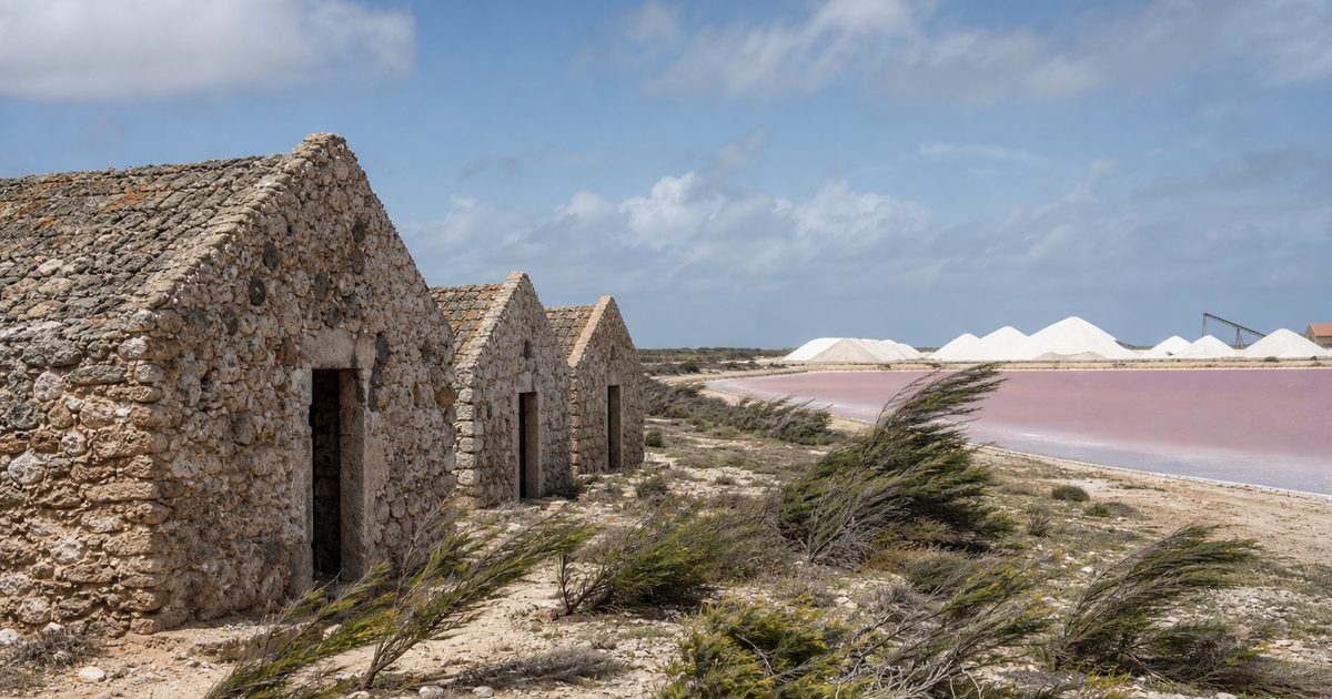
The remains of that system still stand in the south, and they are among the clearest historical markers on the island. Four obelisks, painted in red, white, blue, and orange, once helped ships identify loading points. Nearby sit the small slave huts, built of coral stone in 1850. They are striking because of their scale. Each was about 1.5 meters high, with no real room for comfort and scarcely room for dignity. Their size makes abstraction impossible.
After the abolition of slavery in 1863, salt production declined sharply. Without forced labor, the old model became far less profitable. Industrial production resumed later in mechanized form. Since the mid-20th century, the southern salt works have operated on a modern scale, and the site is now associated with the large white salt mountains visible from the road. Annual output is commonly described in the range of 300,000 to 500,000 metric tons, with salt purity above 99 percent after washing.
Yet the basic process has changed less than the machinery suggests. Seawater enters the system. Sun, arid air, and wind concentrate it over weeks until salt can be harvested. Bonaire salt still depends on climate before it depends on equipment.
Why the water turns pink
The color in the southern salinas is not a trick of light. In the most saline ponds, brine shrimp flourish, and their presence gives the water its pink cast. It is one of the island’s most photographed sights, but the color is best understood as evidence of extremity. These are waters in which only specialized organisms can thrive.
That same harshness creates habitat. The salt pans and Pekelmeer are important for flamingos, especially the Caribbean flamingo populations that use these hypersaline areas for feeding and breeding. Parts of the nesting grounds are closed to human access, and rightly so. The restriction is not ornamental conservation. It protects one of the few places on Bonaire where these birds can breed with limited disturbance.
This is one of the island’s more revealing contradictions. The southern pans are industrial, but they are not separate from ecology. They are engineered landscapes that have become part of a larger living system. Brine shrimp feed birds. Shallow saline water creates niches that would not exist in the same way elsewhere on the island. The pink salt pans of Bonaire are therefore not just scenic byproducts of salt production. They are places where extraction and habitat now occupy the same ground.
Reefs close to shore
If the south reads as mineral and exposed, the coast reads as biological. Around Bonaire and Klein Bonaire, reefs fringe the shoreline so closely that marine life begins almost at the water’s edge. That accessibility helped build the island’s reputation for Bonaire snorkeling and shore diving, but the deeper point is ecological rather than recreational.
The entire coastline of Bonaire and Klein Bonaire falls within the Bonaire National Marine Park, established in the late 1970s and often described as one of the Caribbean’s oldest marine protected areas. The park covers the reefs, seagrass beds, mangroves, and associated coastal waters. Regulations prohibit anchoring on the reef, spearfishing, and direct contact with corals.
For years, Bonaire’s reefs were cited among the healthiest in the region. The waters support more than 340 fish species and over 60 coral species, including hard corals, soft corals, and sea fans. That richness depends on many small relationships. Parrotfish, for example, do essential work by grazing algae that would otherwise overgrow corals. A reef is not protected simply by drawing a boundary around it. It survives through balances like that.
The island’s marine image can make the system seem stable. It is not.
Protection and decline in the Bonaire coral reef
The difficult truth about the Bonaire coral reef is that formal protection has not prevented severe loss. Coral cover has fallen sharply over the past decades. The article’s own figures make the trend plain: average live coral cover dropped from 24.3 percent in 2019 to 9.1 percent in 2025, and recent averages are described as below 10 percent.
The causes are not mysterious. Scientists broadly point to warming seas, marine heatwaves, coral disease, and the effects associated with El Niño events. Local pressures add another layer: population growth, poor sewage treatment, and runoff from land. Even on an island with a long conservation record, reefs remain vulnerable to stress that arrives through water temperature and water quality alike.
That makes Bonaire useful as a case study, though not an easy one. It shows what local protection can achieve, and what it cannot. Rules against anchoring matter. Limits on fishing matter. Efforts to improve wastewater treatment matter. Restoration work matters too, including coral propagation and outplanting by groups such as Reef Renewal Foundation Bonaire. But none of these measures can fully shield reefs from regional and global warming.
A legal dimension has entered the story as well. A Dutch court ruling acknowledged that the Netherlands has a duty to protect Bonaire from climate impacts. That does not restore coral by itself, but it changes the frame. Reef decline is no longer only a scientific and conservation problem. It is also a matter of governance and responsibility.
The wind that ties it together
On many islands, wind is background. On Bonaire, it is structure.
The north-east trades cool the land enough to make the heat bearable. They also keep the island dry, drive evaporation in the salt pans, and once powered the windmills that moved water through the salt works. On the windward side, those same winds shape Lac Bay, where shallow water and reef protection create the conditions that made Bonaire windsurfing famous.
What matters is not that these are separate uses of the same weather. They are part of one system. The wind links labor history to industrial process, and both to ecology. It helps determine what grows on land, how fast seawater evaporates, how the coast feels, and how the sea is used. On Bonaire, trade winds are not an accessory to the landscape. They are one of its main operating principles.
What the south still makes visible
Drive the southern road and the island’s history remains unusually legible. The obelisks are still there. So are the slave huts, the white salt piles, the pink water, the flamingos moving through restricted salinas. Offshore, the reefs still begin close to land, even as their condition has become more fragile. The same exposed geography that once made salt profitable now frames one of the Caribbean’s clearest examples of a reef system under pressure despite decades of protection.
Some older histories survive elsewhere on Bonaire. The Caquetío, an Arawak-speaking people with ties to the South American mainland, left traces in caves such as Spelonk and Onima. Early Spanish accounts referred to the ABC islands as las Islas de los Gigantes, perhaps in response to the stature of some of the island’s inhabitants. Local legend adds another layer, including the story of Hurricane Tecla and a vanished nunnery said to appear at low tide. That belongs to tradition, not established fact.
The harder evidence lies in the south. Coral stone huts. Navigation obelisks. Salt ponds laid out in geometric basins. A reef line just offshore. Few places show so plainly how geology, climate, colonial power, and ecology can be read in the same view. Bonaire’s southern landscape is not a collection of sights. It is a working record of how salt, coral, and wind have shaped the island together.
FAQ
Why are Bonaire’s salt pans pink?
The pink color comes from organisms that thrive in hypersaline water, especially brine shrimp. Their presence gives parts of the salinas their distinctive color.
What are the Bonaire slave huts?
They are small coral-stone shelters near the southern salt pans, built in 1850 for enslaved workers in the salt industry. They remain one of the island’s starkest colonial-era sites.
Are Bonaire’s reefs still healthy?
They were once considered among the Caribbean’s healthiest reefs, but coral cover has declined sharply. Protection remains in place, yet warming seas, disease, and local pollution continue to cause damage.
What is the role of trade winds on Bonaire?
The trade winds help cool the island, increase evaporation in the salt pans, historically powered salt-work windmills, and shape conditions in Lac Bay.
Is Bonaire outside the hurricane belt?
Bonaire lies outside the main Atlantic hurricane tracks, which generally reduces the risk of direct hurricane impacts compared with many other Caribbean islands.