Quartz glints in the sand at a few coves on Santa Catalina Island, and that small shimmer gives the game away. This is not simply a resort island off Los Angeles. It is a fragment of ancient seafloor lifted into daylight, a place where geology set the terms for everything that followed: which plants took hold, which animals evolved in isolation, and how people first reached and used the island.
That deeper story sits just beyond Avalon’s postcard image. Santa Catalina lies about 35 kilometers south-southwest of Los Angeles and is one of California’s eight Channel Islands. Around 4,000 people live here, mostly in Avalon, the island’s only incorporated city. Yet most of the land is not urban at all. The Catalina Island Conservancy manages 88 percent of the island, and in that protected interior the island’s older structure is still easy to read.
Raised from the seafloor
Santa Catalina Island did not begin as a neat volcanic cone. Its origins lie in subduction, the long process by which the Farallon Plate moved beneath the North American Plate. In that tectonic crush, material from the ocean floor was scraped up, buried, altered, and eventually raised.
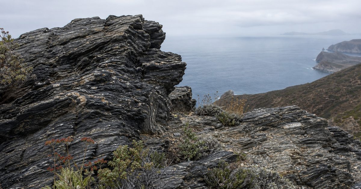
The result is one of the island’s defining features: Catalina Schist. This metamorphic rock, found across much of the western and central island, formed deep within a subduction zone. It is generally dated to the Late Cretaceous, roughly 95 to 109 million years ago. Its metamorphic grades range from blueschist to amphibolite, a technical distinction that matters because it records the pressure and temperature conditions under which the rock changed. What now sits in outcrop once lay far below the surface.
That is why Catalina feels geologically strange even by island standards. The northwestern half preserves some of the clearest schist exposures, including blueschist, a rock associated with subduction environments and uncommon at the surface. The southeastern half tells a different chapter. There, Miocene volcanic and intrusive igneous rocks are more prominent. So the island is not volcanic in origin, but volcanic rock is still part of its structure.
Taken together, those layers make Santa Catalina Island less simple than it first appears. Its ridges and coves belong to a landscape assembled from oceanic material, then reworked by uplift, faulting, and erosion. Even the sand carries traces of that history.
One fact sharpens the ecological story that follows: Catalina was never connected to mainland California. Every plant, every animal, every human arrival had to cross water.
Isolation written in species
On islands, separation becomes biology. Catalina’s distance from the mainland helped produce more than 60 endemic species of plants, animals, and invertebrates, forms of life found nowhere else.
Some are plants that hold to dry slopes and canyon walls with a kind of quiet stubbornness. Catalina ironwood, Catalina manzanita, Catalina liveforever, and St. Catherine’s lace are not decorative curiosities. They are evidence of long isolation and local adaptation. On a mainland, gene flow can blur differences. On an island, difference has room to harden.
The most familiar example is the Catalina Island fox, Urocyon littoralis catalinae, a subspecies found only here. Small islands often favor small mammals, and the island fox is one of the clearest expressions of that pattern in the Channel Islands. On Catalina, it also became the center of a modern conservation crisis.
In 1999, canine distemper virus caused a collapse of more than 90 percent in the fox population. The decline was abrupt. Captive breeding and vaccination followed, and the recovery was unusually fast. The population later rebounded to about 2,162 individuals, above pre-crash levels. By any measure, it was a striking conservation success.
Success, though, does not mean stability. Island ecosystems are easily pushed out of balance. Mule deer, introduced to the island, have damaged native vegetation through heavy browsing. Invasive grasses have altered habitat. Restoration on Catalina is not a matter of preserving some untouched Eden. It is active work in a landscape already changed by people.
That distinction matters elsewhere too. The bison that now roam the interior are not relics of a native past. American bison were introduced in the 1920s, reportedly for a film production, and a managed herd remains on the island. They have become part of Catalina’s visual identity, but not part of its original ecology.
A different return tells a more hopeful story. Bald eagles, once lost from the island after DDT contamination disrupted reproduction, were reintroduced beginning in the late 20th century. Catalina now supports breeding pairs again. On this island, recovery and disruption often occupy the same hillside.
The sea around the island
The shoreline does not end the story. It extends it.
Catalina is ringed by a network of Marine Protected Areas, and the waters around it hold some of the richest habitats in the region. Kelp forests are the most conspicuous. In them live garibaldi, California sheephead, kelp bass, moray eels, and horn sharks, among many other species. The kelp itself builds the structure. It slows current, filters light, and creates vertical habitat in a place that might otherwise seem open and bare.
This marine setting helps explain the island’s history as much as its ecology. A place never joined to the mainland could only be settled, traded with, exploited, or protected by sea. Catalina’s story has always been maritime, but not in a single way. The water has served as highway, barrier, pantry, and border.
Pimu before Catalina
Long before the island was called Santa Catalina, the Tongva knew it as Pimu. The island’s Indigenous people are also referred to as Pimugnans, and the older name matters because it restores the place to a history that predates Spanish naming and American tourism by millennia.
Archaeologists agree that Native settlement on the island is ancient, though the earliest date remains debated. Some evidence points to at least 7,000 years ago; other interpretations support a longer timeline of around 8,000 years. The exact number is less important than the scale of time involved. Human life on Pimu reaches far deeper than the resort era that now dominates the island’s public image.
What stands out is not simply antiquity, but maritime skill. Tongva communities established villages at places including the Isthmus, Avalon, Little Harbor, and Emerald Bay. They quarried soapstone, or steatite, on the island and traded it widely. That stone was prized for making vessels, and Catalina’s quarries tied the island into a broader exchange network across the Southern California coast.
Movement made that trade possible. The Tongva crossed the channel in ti’ats, plank canoes built for seafaring. That detail changes how the island should be understood. Pimu was separated by water, but it was not isolated in the simple sense. The sea connected it to other islands and to the mainland. What looks remote on a map was once part of a practiced Indigenous maritime world.
The Soapstone Quarry remains one of the clearest physical links to that history. It is not just an archaeological site. It is evidence that the island’s value long predated tourism, and that its earliest economy depended on skill, navigation, and regional exchange rather than on spectacle.
Renaming and extraction
European contact brought a different use of the island. Juan Rodríguez Cabrillo reached it in 1542 and claimed it for Spain, naming it San Salvador. In 1602, Sebastián Vizcaíno visited and renamed it Santa Catalina, honoring Saint Catherine.
The names changed. So did the logic of occupation.
In the centuries that followed, the island was used for otter hunting, ranching, smuggling, mining, and military purposes. During the 19th century, many Catalina Tongva relocated to the Los Angeles area under the pressures of the Mexican era and its aftermath. The island’s position off the Southern California coast made it useful, and usefulness often meant extraction or control.
That history should not be flattened into a single narrative. The Indigenous maritime world of Pimu and the colonial use of Santa Catalina both depended on the sea, but they did not treat the island in the same way. One built durable networks of settlement and trade. The other more often treated the island as a resource, waypoint, or possession.
Protection, with limits
The modern image of Catalina took shape when William Wrigley Jr. bought the island in 1919 and developed Avalon as a resort center. That chapter still frames how many people imagine the place. Yet the more consequential decision for the island’s long-term future came later, when most of the land passed into conservation management.
The Catalina Island Conservancy was established in 1972, and 88 percent of the island is now under its care. That scale of protection is unusual and important. It has allowed large parts of the interior to remain ecologically intact enough for restoration, research, and species management.
Protection here does not mean unrestricted access dressed up as wilderness. The interior is managed carefully. Permits and guided access help limit pressure on habitats that are biologically rich and easily damaged. That restraint is part of the story, not an inconvenience beside it. On islands, small disturbances can have large effects.
Seen this way, the protected landscape is not a backdrop to Avalon. It is the main text. The schist outcrops, endemic plants, fox recovery, and archaeological sites all depend on a form of stewardship that accepts fragility as a fact.
What Santa Catalina Island reveals
A place like this can be misread if you only take it at surface value. Santa Catalina Island is often presented as leisure first, nature second. The land suggests the reverse.
Its rocks show a piece of ancient ocean floor transformed under pressure and lifted into air. Its plants and animals show what long separation can produce, and how quickly island life can unravel when disease or introduced species enter the system. Its older human history shows that water did not make Pimu remote. It made it navigable, connected, and economically important long before the first resort brochures or ferry schedules.
That is the island’s deeper coherence. Geology shaped isolation. Isolation shaped ecology. The sea shaped human life throughout.
The silver-grey sand was the clue from the beginning.
FAQ
How was Santa Catalina Island formed?
Santa Catalina Island formed through tectonic processes linked to subduction. Rock and sediment associated with ancient ocean floor were buried, altered, and later uplifted.
What is Catalina Schist?
Catalina Schist is a metamorphic rock found on much of the island, especially in the western and central areas. It dates to roughly 95 to 109 million years ago.
Who lived on Catalina Island first?
The Tongva, including the Pimugnans of Pimu, were the island’s Indigenous inhabitants. Archaeological evidence shows settlement reaching back at least 7,000 years, and possibly longer.
Why is Catalina Island important for wildlife?
Its long isolation helped produce more than 60 endemic species. The best-known is the Catalina Island fox, which recovered after a severe population crash caused by canine distemper virus.
Are the bison on Catalina native?
No. American bison were introduced in the 1920s and remain as a managed herd in the island interior.