A narrow passage of water can decide the fate of whole islands. In the Virgin Islands, that is the thread that ties together everything else: Indigenous settlement, European conquest, plantation slavery, rebellion, colonial transfer, and the later turn to tourism. The archipelago’s history is often introduced with 1493, when Christopher Columbus saw the islands on his second voyage and named them “Virgenes.” But the deeper story is less about a single arrival than about location.
Set just east of Puerto Rico, where the Caribbean Sea meets the Atlantic approaches, the Virgin Islands occupied a useful and dangerous position. Across dozens of islands, cays, and rocks, harbors, channels, and anchorages mattered as much as fertile land. Powers that wanted to move goods, people, and warships through the northeastern Caribbean kept finding reasons to care about these small islands. The sea did not sit in the background of Virgin Islands history. It was the main force shaping it.
Before Columbus, the sea already linked the islands
Long before European ships entered these waters, the archipelago was inhabited. The dates of earliest settlement remain debated. Some evidence suggests very early occupation in what are now the British Virgin Islands, possibly around 1500 BCE. Other scholarship places Arawakan-speaking communities in what are now the U.S. Virgin Islands by about 1000 BCE. The uncertainty matters, because it reminds us that the first chapter is archaeological rather than fully written.
By about 400 BCE, Saladoid or Igneri people had arrived from South America. They brought agriculture as well as seafaring. Crops such as yucca and cassava show that these were not temporary camps left by passing fishers. They were settled landscapes, worked and known.
Later, between about 700 and 1000 CE, Taíno communities expanded in the islands and built more complex village life. Their world survives in traces that are still legible. On St. John, the petroglyphs near Reef Bay are among the clearest signs of sacred practice in the pre-Columbian Virgin Islands. In Taíno belief, carved figures could represent ancestral caciques, and zemis were associated with power over weather, crops, hunting, wealth, and childbirth. The sea connected these communities to the wider Antilles, but it did not reduce the islands to waystations. They were homes.
By the fifteenth century, Kalinago people had also entered the region. Older colonial histories framed this as a simple replacement of “peaceful Arawaks” by “warlike Caribs.” Historians have long challenged that version. It reflects European stereotypes more than the full complexity of Indigenous life in the northeastern Caribbean.
Conquest followed the shipping lanes
When Columbus reached the islands in 1493, he became the first European known in written records to have seen them. He also had a violent encounter with Indigenous people on St. Croix. That moment quickly fed into the logic of conquest.
In 1512, the Spanish Crown authorized settlers to hunt and kill so-called Caribs in the region. That decree formed part of a wider pattern of colonial violence. Disease, enslavement, warfare, and displacement devastated Indigenous communities across the archipelago. By the late sixteenth century, the Indigenous population of the Virgin Islands had been largely destroyed.
That catastrophe changed how European powers viewed the islands. Once the original inhabitants had been reduced by violence and disease, the archipelago was increasingly treated not as a set of inhabited homelands but as a chain of strategic points. Anchorage, surveillance, supply, and access to trade routes became central. In that sense, conquest and maritime strategy were inseparable.
Why these islands mattered to empires
The Virgin Islands did not become important because they were large. They became important because they sat in the right place.
A revealing early example comes from 1563, when Sir John Hawkins passed through with enslaved Africans bound for Hispaniola. This was before full European settlement in the British Virgin Islands. The detail is grim, but useful. It shows that the islands had already entered the traffic of the Atlantic world through shipping routes before colonial administration had fully taken hold.
Their position east of Puerto Rico placed them near key passages through the northeastern Caribbean. Ships moving between the Greater and Lesser Antilles, or between Atlantic and Caribbean waters, could use these islands for shelter, trade, repair, raiding, or resupply. A good harbor could be worth more than a broad interior.
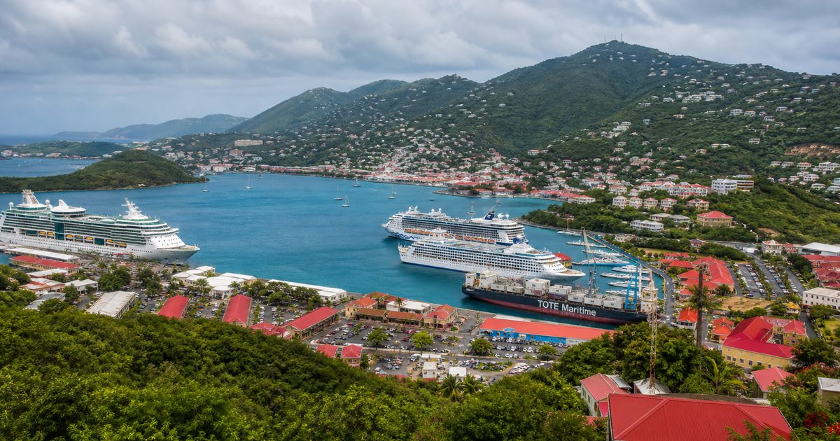
St. Thomas became the clearest example. Under Danish rule, it developed into a free port and a major commercial center. Charlotte Amalie, with its harbor facing one of the best anchorages in the region, grew through maritime trade, privateering, and the slave trade. The town’s importance was not accidental. It came directly from the way sea routes converged there.
This is the central fact of Virgin Islands history: empires did not value the archipelago despite its small size. They valued it because small islands in the right water can control movement far beyond their shores.
Danish rule turned maritime value into plantation wealth
In what are now the U.S. Virgin Islands, Denmark became the most durable colonial power. The Danish West India Company established St. Thomas as a colony in 1672. In the same early period, a slave market took shape in Charlotte Amalie, tying the island’s harbor to the wider Atlantic slave trade.
The company then expanded. It took St. John in 1717, secured it formally in 1718, and bought St. Croix from France in 1733. These were not just territorial additions. They formed a colonial system built on shipping, sugar, and enslaved labor.
St. Croix became the plantation island on the largest scale. In the late eighteenth and early nineteenth centuries, enslaved people made up about 88 percent of its population. Sugar cane and rum drove the economy. The sea carried both the products outward and captive Africans inward. Maritime geography and plantation slavery worked together. One made the other profitable.
The British Virgin Islands followed a related pattern, though under different rulers. On Tortola, the first recorded reference to enslaved people dates to 1665, when the British privateer John Wentworth attacked Dutch settlers and seized 67 enslaved people. Across the archipelago, land and labor were folded into a system that treated human beings as cargo and islands as assets.
The modern population of the British and U.S. Virgin Islands still reflects that history of forced migration. Demography here is not an abstract statistic. It is one of the clearest living records of the plantation era.
The sea carried rebellion too
Colonial power in the Virgin Islands was never secure. Enslaved people resisted it repeatedly, and some of the most important turning points in the islands’ history came from revolt.
On St. John in 1733, enslaved Africans led what is often called the Akwamu revolt. The uprising lasted for months and disrupted plantation production on a scale the colonial regime could not ignore. Economic records tend to describe such events in terms of lost output. That language misses the deeper point. The rebellion struck at the system’s foundation by refusing the labor on which it depended.
A century later, St. Croix saw an even more decisive break. In 1848, enslaved people gathered in Frederiksted and demanded freedom. The uprising is closely associated with Moses Gottlieb, known as General Buddhoe. Under that pressure, Governor Peter von Scholten declared emancipation in the Danish West Indies. Fort Frederik still marks the place where that demand for freedom entered public history.
The distinction matters. Slavery did not end in the Danish islands as a gift from above. It ended in the context of organized resistance from below.
After emancipation, the plantation economy weakened sharply. Sugar no longer delivered the same returns, and the Danish colony entered a long period of decline. Yet even this downturn had a maritime dimension. Once the islands became less useful as plantation exporters, their strategic value remained.
Great powers kept returning to the map
European wars repeatedly reached the Virgin Islands because control of Caribbean waters mattered far beyond the Caribbean.
During the French Revolutionary Wars, Britain occupied the Danish West Indies from 1801 to 1802. During the Napoleonic Wars, British forces again took St. Thomas and St. Croix, holding them from 1807 to 1815. These occupations were not side notes. They show how closely the islands’ fate was tied to naval strategy.
The United States later saw the same advantage. In 1867, Secretary of State William H. Seward tried to acquire the Danish West Indies, though the transfer failed. The idea did not disappear. In 1917, the United States bought the islands from Denmark for $25 million in gold coin and renamed the territory the Virgin Islands of the United States.
The timing reflected wartime strategy. Washington wanted to prevent any hostile naval power from gaining a foothold near the approaches to the Panama Canal and the Caribbean basin. Once again, the islands changed hands because of their position on the water.
Strategic possession did not mean full political equality
The transfer to the United States changed sovereignty, but it did not erase the territory’s distinct status.
In 1927, U.S. citizenship was granted to many inhabitants of the U.S. Virgin Islands. A 1932 law extended citizenship more broadly to natives of the islands residing in the continental United States or U.S. territories. Yet residents of the territory still do not vote for the president in the way residents of the states do.
That gap is part of the same long pattern. The islands have often been highly valued for strategy while remaining only partly incorporated on political terms. Maritime importance brought attention, investment, and control. It did not automatically bring equal power.
The routes changed, but the logic stayed the same
After the Second World War, the traffic moving through the Virgin Islands changed character. Naval rivalry and sugar exports mattered less. Tourism and cruise travel mattered more.
A key shift came after the 1959 Cuban Revolution and the later U.S. embargo on travel to Cuba, which helped redirect American tourism toward other Caribbean destinations, including the U.S. Virgin Islands. The archipelago’s location, once prized by empires and merchants, now served airlines, cruise companies, and leisure markets.
That does not mean the old maritime logic disappeared. It simply changed form. The same harbors that once welcomed privateers and slavers now receive cruise ships. The same strategic position that once drew imperial fleets now draws mass tourism. Movement across water still determines the islands’ economy, their infrastructure, and the pressure placed on their landscapes and historic sites.
Even the visible remains of the past follow this pattern. Charlotte Amalie still bears the imprint of port commerce. Plantation ruins on St. Croix mark the sugar economy that shipping sustained. Reef Bay’s petroglyphs on St. John recall an older island world, one connected by canoe routes rather than European sea lanes. Different eras, same underlying fact: the Virgin Islands have long been shaped by who could move through these waters, and on what terms.
FAQ
Who lived in the Virgin Islands before Columbus?
Indigenous peoples lived in the archipelago long before European arrival, including Saladoid or Igneri communities, later Taíno groups, and Kalinago people.
Why were the Virgin Islands strategically important?
Their location east of Puerto Rico placed them near important shipping lanes in the northeastern Caribbean, making their harbors valuable for trade, naval control, and resupply.
When did the United States buy the Virgin Islands?
The United States purchased the former Danish West Indies in 1917 for $25 million in gold coin.
What role did slavery play in Virgin Islands history?
It was central to the colonial economy. St. Thomas was a slave-trading port, and plantations on islands such as St. Croix depended on enslaved African labor.
Are people in the U.S. Virgin Islands U.S. citizens?
Yes. Citizenship was granted in 1927 and expanded by law in 1932, though residents of the territory do not have the same voting rights in presidential elections as residents of U.S. states.