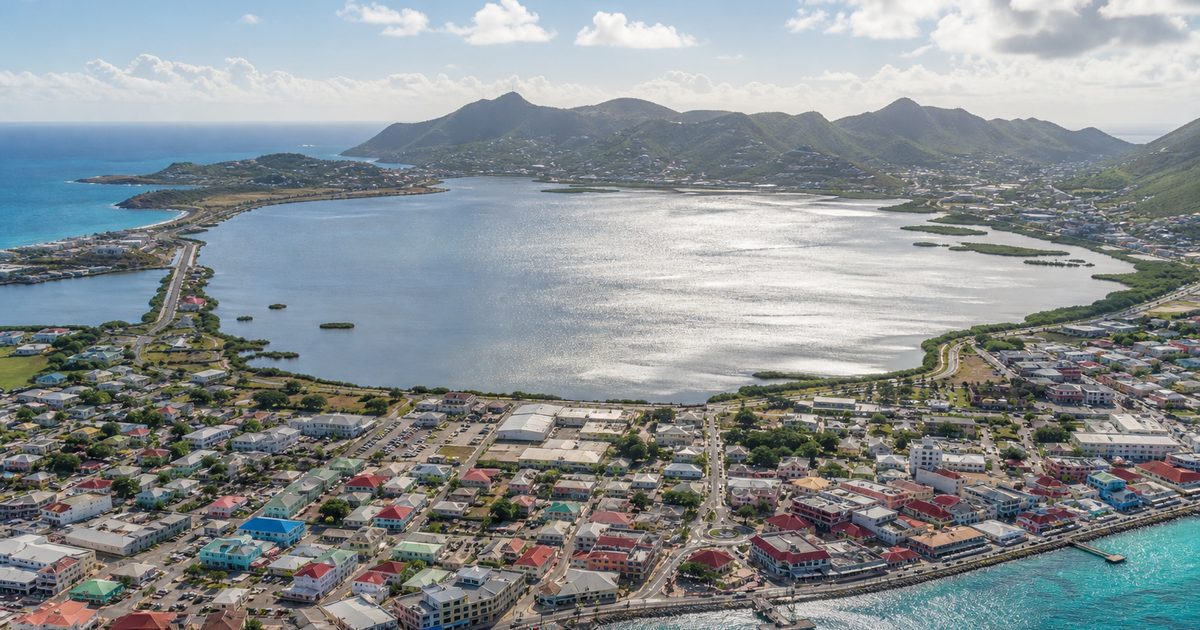
A line between two countries runs across this island, yet most people cross it without noticing. The stranger fact lies underneath: the border makes sense only because of salt.
On Saint Martin, shared with Sint Maarten, politics followed landscape. Shallow ponds, dry heat, sheltered anchorages and an old volcanic frame turned a small Caribbean island into a place worth contesting. The open frontier that visitors notice today did not begin as an enlightened experiment. It grew out of a practical problem: how two colonial powers could divide a place whose most valuable resource sat in coastal basins neither side wanted to lose.
Soualiga and the meaning of salt
Before European names and claims, the island was known as Soualiga, often translated as “Land of Salt.” That name is one of the clearest clues to its early importance. Salt pans were not some later colonial discovery. They already defined the island strongly enough to shape how people spoke of it.
Human settlement here reaches back far beyond the colonial period. The earliest inhabitants arrived roughly 3,500 years ago. Later, Arawakan-speaking groups who had moved north from the Orinoco basin were present on the island by around 800 CE. Before Europeans arrived, Kalinago people had displaced earlier Arawakan-speaking populations. The broad sequence is established, even if the details of each migration remain less certain than older histories once claimed.
What matters for this story is simple. Long before treaties and forts, people recognized the value of the island’s salt ponds. Soualiga was not a poetic flourish. It described a resource.
That matters because Saint Martin did not fit the usual shorthand for Caribbean history. Sugar would later shape much of the region, but here salt came first. The island entered European imperial competition not mainly as plantation land, but as a place where seawater, sun and shallow basins could produce something every maritime power needed.
A small volcanic island with useful edges
The island’s geology set the terms. Saint Martin is volcanic in origin, with bedrock that includes andesite tuff and tuff breccia. Later intrusions of quartz diorite cut into those older rocks. Over much longer spans of time, changes in sea level and land exposure linked this island with Anguilla and Saint Barthélemy on the Anguilla Bank before partial submergence separated them.
That deep history shaped the surface people would later exploit. The island rises steeply in places, with Pic Paradis reaching 424 meters on the French side, but the economic story happened lower down. Coastal depressions and enclosed flats allowed seawater to collect and evaporate. In the northeastern Caribbean, where steady sun and wind do much of the work, such ponds could become salt works with relatively little technological complexity.
Geography did more than provide raw material. It also gave the island a position on maritime routes through the Lesser Antilles. Ships needed preserved food. Preserved food required salt. A small island with accessible pans and workable anchorages could therefore matter far beyond its size.
That is the real beginning of the story behind the Saint Martin border. The line came later. The resource came first.
Why empires cared
Christopher Columbus sighted the island on 11 November 1493 during his second voyage and named it Isla de San Martín, after Saint Martin of Tours. Spain claimed it, but did not invest heavily in settlement. That left room for rivals.
By the early seventeenth century, Dutch interest had sharpened around the Great Salt Pond. In 1631 they established a settlement, built Fort Amsterdam and began organized salt extraction. The attraction was plain enough. Salt preserved meat and fish for long voyages and naval use. It was a strategic commodity, not a minor local product.
The French were also present early on the northern part of the island. Their foothold, like the Dutch one, reflected the same logic: Saint Martin offered a useful harboring point and a resource that fed wider Atlantic trade.
Spain intervened in 1633, capturing the island from the Dutch and building a fort at Point Blanche, now known as the Old Spanish Fort. Yet the Spanish hold did not last. When the Eighty Years’ War ended in 1648, Spain no longer needed the island in the same way and appears to have judged it insufficiently profitable to maintain.
That withdrawal opened the way for the arrangement that still defines the island.
The treaty was about access, not abstraction
On 23 March 1648, French and Dutch representatives signed the Treaty of Concordia. It divided the island between them, roughly 53 square kilometers to the French side and 34 to the Dutch. Today that makes Saint Martin and Sint Maarten the smallest inhabited island shared by two states, France and the Netherlands.
The treaty is often presented as a diplomatic curiosity. In fact, it was an economic settlement shaped by terrain. One practical provision allowed both parties access to the salt pans. That clause says more than any romantic retelling. The border was not drawn in spite of the landscape, but because of it.
A well-known local legend offers a neater explanation. In the story, a Frenchman and a Dutchman began from the same point and walked in opposite directions around the coast; where they met fixed the boundary. The Dutch side’s smaller share is sometimes blamed on cheating, drink or a shortcut. It is a durable island tale, but still a tale. The legal basis lies in the treaty, not in a race on foot.
The open border that people associate with the island today also has older roots than it first appears. This was a place organized by movement across water, by labor around ponds, by exchange between settlements. A hard internal barrier would have worked against the geography that made the island useful in the first place.
Salt built towns and demanded labor
The Dutch side’s main town grew directly from this economy. In 1733, John Philips founded Philipsburg in a position that served the transport of salt from pond to ship. Urban form followed extraction.
By the middle of the nineteenth century, production on the Dutch side had reached 337,000 barrels a year. Figures like that can make the industry sound abstractly efficient. It was nothing of the kind. Salt harvesting depended on hard physical labor carried out largely by African-descended workers within a colonial system built on coercion and exploitation.
That history should be stated plainly. Wealth from the pans did not emerge from climate and geography alone. It came through forced labor and unequal power.
The chronology of emancipation on the island reflects the split sovereignty. France abolished slavery on its side on 27 May 1848. Dutch emancipation followed in 1863, fifteen years later. The difference mattered in lived experience, not just in legal record. Many families on Sint Maarten and Saint Martin trace their history to people who worked the salt ponds under those systems.
This is why the old industry still carries weight in local memory. Salt is not just an early export. It sits inside the island’s social history.
A border that endured because the island stayed connected
Empires changed hands often in the Caribbean, and this island was no exception. The French part passed to the Order of Saint John in 1651 and returned to French commercial control in 1665. Across the eighteenth and nineteenth centuries, occupations and restitutions repeatedly altered who governed what.
Yet the division itself survived.
That durability can look surprising on a map, but it becomes easier to understand on the ground. The island was small, maritime and economically interdependent. Its settlements faced outward to sea routes, but they also depended on access across the interior. The border lasted because it accommodated a shared landscape rather than trying to sever it cleanly.
That is also why the frontier feels less like a scar than a habit. It is political, certainly. It is also ordinary, folded into daily movement.
After the salt era
Commercial salt production did not continue indefinitely. On the Dutch side it ended in the late 1940s. On the French side it lasted into the 1960s.
The sea remained central after that, but in a different way. Instead of carrying out barrels of salt, it became the setting and infrastructure for a tourism economy. Cruise ships, beaches, marinas and airport access replaced the old export logic. The shift brought money, but also pressure on a very small island. Coastal development, waste and coral degradation became part of the new story.
That later transformation matters here only because it throws the older landscape into relief. The same ponds and shorelines that once served extraction now sit inside a different economy. Their meaning changed, but their physical presence did not.
What survives in the landscape
The Great Salt Pond still anchors the island’s historical geography, especially on the Dutch side. It remains the clearest reminder that Philipsburg was not placed where it is by chance. The town grew in relation to the pond and the trade it supported.
Elsewhere, fragments of the salt industry remain visible in old walls, industrial traces and place names. On the French side, Grand Case preserves a salt grinder associated with that earlier economy. Fort Amsterdam still marks the Dutch effort to defend access to the island and its maritime approaches. The Old Spanish Fort at Point Blanche recalls the brief Spanish seizure in 1633.
Then there is the border itself, still the most unusual remnant of all. No checkpoint, no formal interruption, just a line that survives because the island learned long ago to live with one.
That line is not entirely frozen in seventeenth-century form. A later agreement settled parts of the boundary more precisely, including adjustments involving Oyster Pond and modern geographic coordinates. Even so, the deeper logic remains unchanged. The frontier exists because a small volcanic island, ringed by sea and marked by salt ponds, could not be divided without also being shared.
Saint Martin is often introduced through its dual nationality. The more revealing fact is older and simpler. Salt made the island worth claiming, and the shape of the island made sharing it unavoidable.
FAQ
Why is Saint Martin divided between France and the Netherlands?
The island was divided by the Treaty of Concordia in 1648 after French and Dutch interests converged on the same small territory, especially its valuable salt pans.
What does Soualiga mean?
Soualiga is commonly translated as “Land of Salt,” reflecting the importance of the island’s salt ponds before European colonization.
Was salt really that important on Saint Martin?
Yes. For centuries, salt was one of the island’s main economic resources and a key reason European powers settled and contested it.
Can you cross the border between Saint Martin and Sint Maarten freely?
Yes. The border is open, and people generally cross between the French and Dutch sides without checkpoint controls.
What is the Great Salt Pond?
The Great Salt Pond is a large coastal pond near Philipsburg that was central to the island’s salt industry and to the development of the Dutch side.