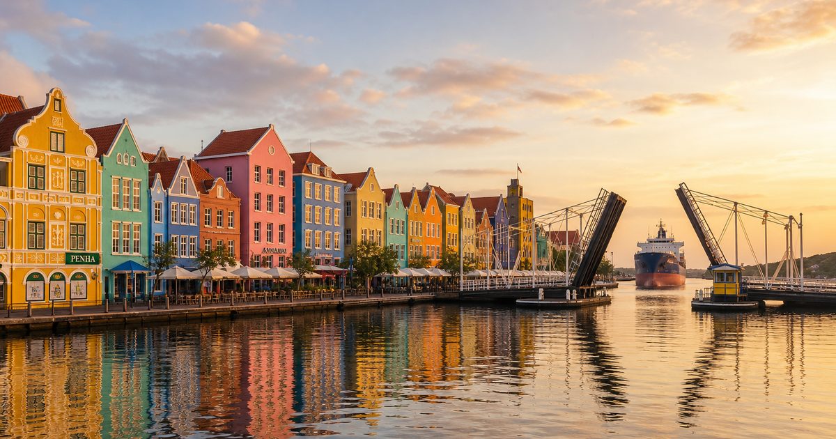
A ship approaches St. Anna Bay, the bridge swings open, and foot traffic pauses at the water’s edge. In that brief interruption, Willemstad explains itself. The city still gives way to the harbor.
That priority is the key to reading the historic center of Curaçao. The UNESCO-listed Historic Area of Willemstad, Inner City and Harbour was recognized for more than its painted waterfront. What survives here is a port city whose form still follows the demands of anchorage, defense, trade, and movement. The deep basin of the Schottegat, linked to the sea by the narrow channel of St. Anna Bay, made this possible. Around that geography grew a colonial capital, a mercantile society, and a built landscape marked by exchange, coercion, migration, and adaptation.
Willemstad matters because its streets and quays still show how a harbor can shape a city over centuries.
A useful harbor before a city
Long before Dutch rule, Curaçao was tied to the South American mainland. The island was inhabited by Arawak and Caquetio communities, and its older connections ran across the water as much as within the Caribbean. Archaeological evidence links Curaçao to the Dabajuroid cultural series associated with the Lake Maracaibo region of present-day Venezuela, with roots reaching back to around 1800 BCE.
That earlier history matters. It keeps the story from beginning with Europeans and reminds us that the island was already part of regional exchange. Fishing, agriculture, and trade connected Curaçao to neighboring islands and the mainland long before Willemstad existed.
The Spanish arrived at the end of the 15th century. Alonso de Ojeda reached the island in 1499. But the decisive turn came in 1634, when the Dutch West India Company seized Curaçao from Spain and fixed its attention on one thing above all: the harbor.
Why the Dutch settled here
The Dutch did not choose this site for scenery. They chose it because the Schottegat is one of the most workable natural harbors in the southern Caribbean.
The inland basin offered sheltered deep water. St. Anna Bay gave ships a narrow entrance to the sea that could be watched, defended, and controlled. For a trading company, that combination was ideal. Cargo could be handled in relative safety, fleets could anchor inland, and the settlement could be organized around maritime traffic.
Fort Amsterdam rose almost immediately. Construction began in 1634 and was completed by 1635 or 1636. The fort was not simply a military post. It concentrated administration, defense, and commerce in one place. That set the pattern for Willemstad from the start: a city in which government and trade stood close to the water and close to each other.
Near the fort, the Dutch laid out the first walled town, now known as Punda. Its plan drew on Dutch urban habits, but the setting forced adjustments. Buildings had to answer to heat, glare, and salt air. Storage, supervision, and shipping mattered as much as domestic life. The result was never just a transplanted Dutch town. It was a Dutch Caribbean port, shaped by local climate and by the Atlantic economy it served.
A port built on forced movement
Any account of Willemstad’s harbor history has to reckon with slavery plainly.
By 1648, the Dutch had begun importing enslaved Africans to Curaçao, and the island became a significant hub in the Atlantic slave trade. The harbor’s usefulness to the Dutch West India Company was inseparable from that role. Ships did not move only sugar, salt, timber, and manufactured goods through this port. They also moved people who had been captured, sold, and forced across the ocean.
That history sits behind the city’s orderly facades. Warehouses, quays, forts, and merchant houses were part of a system of profit and control. In port cities, architecture often looks calm long after the violence that financed it has been softened by time and paint. Willemstad is no exception.
Slavery in Curaçao was abolished in 1863. By then, more than two centuries of colonial trade had already shaped the harbor and the town around it.
The mercantile Jewish city
One of the clearest signs of Willemstad’s role in Atlantic commerce is the early presence of a Sephardic Jewish community.
In 1651, the first Jewish families from Amsterdam settled on Curaçao and established Congregation Mikvé Israel. In 1659, another group arrived from Brazil, bringing a Torah scroll with them. These were not incidental arrivals. They were part of a wider Sephardic trading world that stretched across the Atlantic, linking Dutch territories, Iberian Jewish diasporas, and maritime commerce.
By the late 17th century, the community had moved into the walled town and turned increasingly toward trade and shipping. That shift tells its own story. The harbor did more than receive vessels. It drew in communities whose livelihoods depended on credit, cargo, correspondence, and sea routes.
The Mikvé Israel-Emanuel Synagogue remains one of the strongest expressions of that history. Consecrated in 1732, it is widely recognized as the oldest continuously operating synagogue in the Americas. Its sand-covered floor is often the first detail visitors remember. The sand is usually understood as a symbolic reference to the Israelites’ years in the desert; it is also sometimes linked, in communal memory, to older traditions of muffling sound in times of persecution. What matters here is that the building is not an isolated curiosity. It belongs to the working history of a harbor city shaped by Sephardic migration and mercantile life.
In 1964, Congregation Mikvé Israel merged with the Reform congregation Emanu-El, forming the present Mikvé Israel-Emanuel community. The institution did not become a relic. It continued.
Across the bay
Ports grow by crossing their own boundaries. Willemstad did that early.
In 1707, Otrobanda was founded across St. Anna Bay from the original walled town. The name means “the other side” in Papiamentu, and it is as practical as port-city language often is. Punda remained the older commercial core. Otrobanda developed in relation to it, with its own streets, houses, and social life, but always in conversation with the water between them.
For much of that history, the bay was both link and obstacle. That changed in 1888 with the construction of the Queen Emma Bridge, the floating pontoon bridge that still defines the daily rhythm of the channel. Few structures explain Willemstad more clearly. It connects the two sides, but it also yields whenever shipping requires passage. Even now, the Queen Emma Bridge makes visible the old hierarchy: harbor first, city second.
Locals call it the Swinging Old Lady. The nickname suits it. The bridge is mechanical, familiar, and faintly theatrical, but its importance is practical. It turned crossing into an ordinary act of urban life.
For a period, it was also a toll bridge. Between 1901 and 1934, pedestrians paid to cross, except for those without shoes, who were allowed through free of charge. It is a small detail, but a revealing one. Infrastructure is never just engineering. It also records class, custom, and the terms on which a city lets people move.
Since 1974, the bridge has been reserved for pedestrians, while motor traffic uses the Queen Juliana Bridge. The old pontoon crossing remains the more eloquent structure. It still opens for ships in Willemstad, and each opening repeats the city’s founding logic.
Color on the waterfront, language in the streets
The row of buildings along Handelskade is one of the best-known images in Curaçao: narrow facades, bright paint, a line of gables facing the water. Yet the color can distract from what the waterfront actually is. This was a working commercial edge, not a decorative set piece.
The painted buildings have their own lore. A popular local story says they were once white and that a doctor persuaded the authorities to require color because sunlight reflecting off the facades caused headaches or eye strain. It is a legend rather than an established historical explanation, but it has lasted because it feels plausible in this climate and because it turns appearance into a civic anecdote.
Whatever the origin of the custom, the city’s visual identity comes from more than paint. Dutch forms were adapted to Caribbean conditions and then altered again by the people who used them. African, Spanish, Portuguese, and Jewish influences all left marks on the built environment. The result is not a pure style. It is a port style, formed by contact.
The same layering appears in language. Papiamentu, one of Curaçao’s official languages, developed in a world of trade, migration, enslavement, and colonial rule. It is generally understood as a Creole language with strong Portuguese and Spanish elements and substantial Dutch influence, though scholars continue to debate its precise formation and the weight of links to West African and Cape Verdean creoles. That uncertainty is part of the point. The language, like the harbor, belongs to a contact zone.
When the walls fell and oil arrived
Willemstad did not remain a compact fortified town forever. In 1861, the city walls were demolished to allow expansion. The change was practical, but it also marked the end of one urban phase. A walled mercantile settlement had to become a larger city.
Another transformation followed in the early 20th century, when oil from Venezuela reshaped Curaçao’s economy. The harbor entered an industrial era. Its older commercial role did not disappear, but it was enlarged and redirected by petroleum and refinery activity. Once again, the same geography proved decisive. The port remained useful because the harbor remained useful.
That continuity is easy to miss if Willemstad is treated only as a picturesque colonial center. The city was never static. Trade built it, slavery enriched it for others, migration diversified it, and oil altered its scale. The water stayed constant.
What still survives in plain sight
Some historic cities preserve the past behind glass. Willemstad leaves much of it in daily use.
Punda and Otrobanda still face one another across St. Anna Bay. Fort Amsterdam still stands at the old strategic center and continues to serve governmental functions. Inside the fort complex, in the southwestern wall of the Fort Church, a cannonball from a British attack in 1804 remains lodged in the masonry. It is one of those details that cuts through abstraction. Military history is not interpreted here only in text panels; it is embedded in the wall.
The synagogue still holds its sand-covered floor. The Queen Emma Bridge still swings open. Handelskade still presents its line of merchant facades to the water. These are not disconnected attractions. Together they show how the harbor organized the city’s growth and how that pattern remained legible even as the economy changed.
That legibility is part of why UNESCO recognized the historic area in 1997. Protection matters, but designation alone does not solve everything. Old buildings need maintenance. Historic centers struggle with vacancy, pressure on infrastructure, and the challenge of keeping living urban districts from hardening into scenery.
Willemstad’s real distinction lies here. It is not simply colorful. It is readable. The harbor that made Curaçao valuable to empire still explains the city’s layout, its institutions, and many of its contradictions.
FAQ
Why is Willemstad a UNESCO World Heritage Site?
Because the historic center preserves an unusually clear example of a Dutch Caribbean port city shaped by its harbor, colonial planning, trade, and layered cultural influences.
What is the Queen Emma Bridge in Curaçao?
It is a floating pontoon bridge in Willemstad, opened in 1888, linking Punda and Otrobanda across St. Anna Bay. It swings open to let ships pass.
What made Willemstad’s harbor so important?
The Schottegat provided a deep, sheltered inland basin, while St. Anna Bay connected it to the sea through a narrow, controllable channel. That made the port valuable for trade and defense.
What is the Mikvé Israel-Emanuel Synagogue known for?
The synagogue, consecrated in 1732, is recognized as the oldest continuously operating synagogue in the Americas and is known for its sand-covered floor.
Why are the buildings in Willemstad so colorful?
The exact reason is not certain. A well-known local legend links the colors to complaints about glare from white facades, but that story is not established fact.