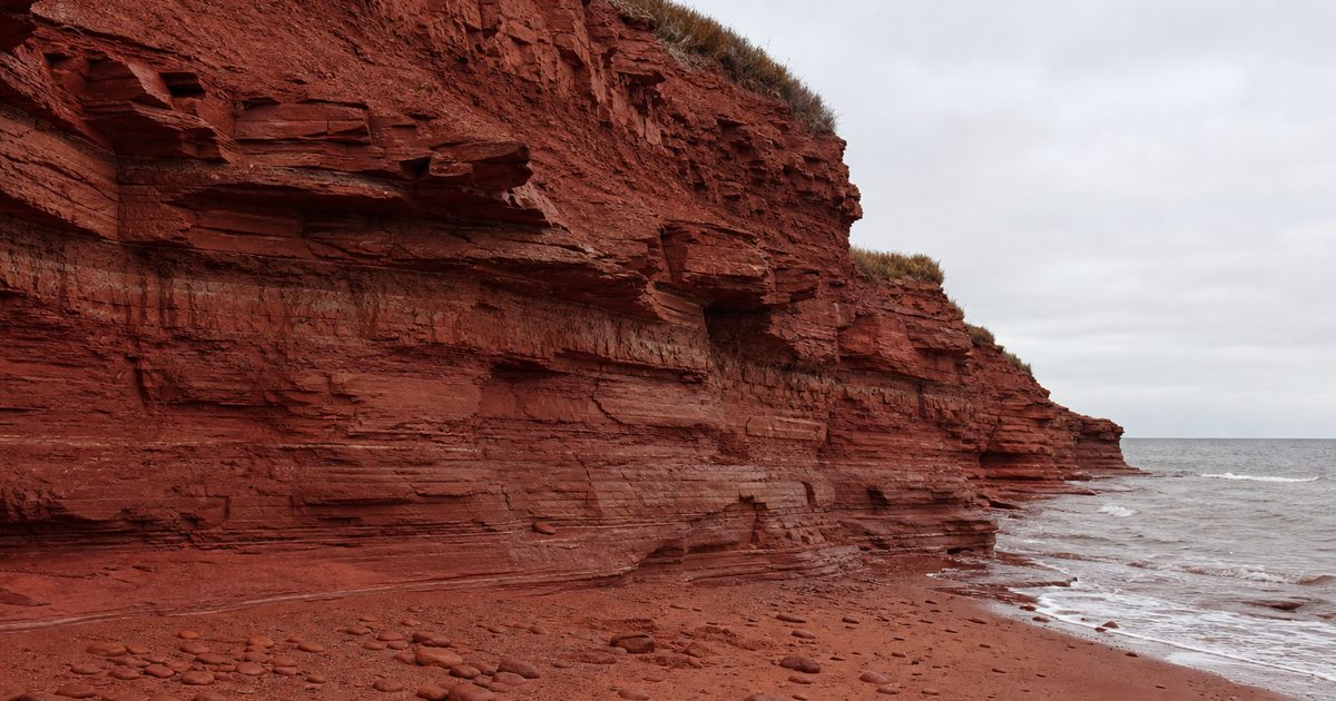
After rain, the cliffs on Prince Edward Island look freshly cut. Red deepens to brick, then to orange where the light catches wet sand. It is easy to treat that color as scenery. It makes more sense to read it as evidence.
On PEI, the red shore and the farmed interior come from the same source: iron-rich sedimentary rock, weathered into soil and exposed again in cliffs and beaches. That link matters because the island’s best-known agricultural landscape did not arise beside its geology. It arose from it. The same oxidized sandstone that gives the coast its color also helped produce the soils that made potato farming so prominent.
This is the deeper story of Prince Edward Island red soil and Prince Edward Island farming: not two separate subjects, but one long chain of cause and effect.
When the island lay near the equator
The bedrock beneath Prince Edward Island was formed between roughly 250 and 300 million years ago, in the late Carboniferous and early Permian. At that time, this part of the world sat much closer to the equator within Pangea. The climate was semi-arid. Rivers crossed broad floodplains and inland basins, laying down sand, silt, and mud in shifting channels.
Over time, those sediments hardened into sandstone, siltstone, and mudstone, with some conglomerate and minor shale. They came from the erosion of older mountains to the south. What survives now is a low island, but its foundation was built out of debris carried by ancient river systems on a very different Earth.
The color came later, though still long before any human saw it. Iron-bearing minerals in the rock reacted with oxygen and oxidized. In plain terms, they rusted. That process stained the stone in shades that run from dull red to a brighter orange-red. As the rock weathered, the same chemistry influenced the soil above it.
So the red cliffs of Prince Edward Island are not a surface effect. They are the visible face of the island’s structure.
Red sandstone, fossils, and water
The sandstone does more than color the coast. It also preserves traces of late Paleozoic life. On the island, fossil-bearing formations have yielded ancient plant remains, fish remains, burrows, other trace fossils, and footprints attributed to early reptiles and amphibians. In places such as PEI National Park, some of these exposures are protected. Fragile cliffs are closed to visitors not for effect, but because erosion can destroy fossil sites as quickly as it reveals them.
The rock has another role that is less dramatic and more important to daily life. Prince Edward Island relies heavily on groundwater stored in porous sandstone aquifers. The same bedrock that records vanished floodplains also holds much of the island’s drinking water.
That gives the geology unusual intimacy. On many coasts, bedrock is something you notice on a headland. Here it sits under fields, shapes the shoreline, preserves fossils, and stores the water used by nearly every community.
How glacial cover became farmland
Bedrock alone did not make the island arable. A cover of glacial till lies over it, ranging from a few centimetres to as much as 20 metres thick. That material became the parent layer for many of the island’s soils.
The resulting earth is often sandy, well drained, and quick to warm in spring. It can also hold moisture well enough to support cultivation. Iron oxide contributes to its distinctive color. These are practical qualities rather than romantic ones, but they explain a great deal about the island’s agricultural history.
One soil type became especially important: the Charlottetown soil series, a deep fine sandy loam recognized as the provincial soil. Its significance is not symbolic. It is widespread and productive, and it helps explain why potatoes became so closely associated with the island.
Potatoes do well in acidic soils, and PEI produces about a quarter of Canada’s potatoes. That figure is usually presented as an agricultural statistic. It is also a geological consequence.
Before plowland: Epekwitk in Mi’kma’ki
Long before European settlement, the island known in Mi’kmaq as Epekwitk formed part of Mi’kma’ki, the wider Mi’kmaq homeland. Mi’kmaq communities used the island’s seasonal resources over many generations, moving through a landscape of shores, rivers, and interior ground according to seasonal patterns.
That history matters because it changes the frame. The land did not become meaningful when settlers began to fence and plow it. It was already a lived homeland, known through use and movement rather than through permanent field systems. Any account of Prince Edward Island agriculture that begins only with European farming leaves out the longer human relationship with the island.
The first cultivated ground
European agriculture on the island began under French settlement. The first continuous settlement at Port La Joie dates to 1720. Early cultivation remained local, especially along the Hillsborough River and around St. Peters, Savage Harbour, Tracadie, and Malpeque.
By 1752, European settlers had an estimated 1,000 acres under cultivation, mainly near coasts and salt marshes. That pattern reflects the realities of settlement. Coastal margins offered access, transport, and workable ground close to where people lived.
The scale was still limited. Even so, the direction was clear. Soil formed from weathered sandstone and glacial deposits was being drawn into an agricultural system that would eventually dominate the island’s interior.
Working with an acidic soil
The red earth was productive, but it was not effortless. Its natural acidity suited some crops, especially potatoes, yet it also required adjustment for other kinds of farming. Early settlers used mussel mud, a clay rich in mussel and oyster shell, to temper that acidity. Lime later became the more common amendment.
This detail says a lot about the island’s farming culture. Agriculture here did not simply benefit from a ready-made fertile landscape. Farmers had to learn the chemistry of the ground and answer it with local materials. Even soil improvement carried the imprint of the coast, with shell-rich mud hauled inland to alter fields.
By the 19th century, the scale of cultivation changed sharply. Between 1830 and 1880, the European settler population rose from about 32,000 to nearly 109,000. Over the same period, improved agricultural land expanded from 95,000 acres to 597,000 acres.
Those numbers describe more than growth. They describe conversion. Forest and uncultivated land gave way to a working countryside, and the red landscape now celebrated in photographs became, in large part, a managed one.
Fewer farms, larger fields
The 20th century altered the pattern again. In 1935, the island had more than 12,000 farms. By 2000, that number had fallen to just over 1,800. Average farm size increased from about 36 hectares, or 90 acres, to 146 hectares, or 360 acres.
That shift changed the look of rural Prince Edward Island and the social life attached to it. The province remained strongly agricultural, but the small-scale patchwork that had once defined much of the countryside gave way to fewer and larger operations. Debates over artificial fertilizers and natural manures sharpened as farming intensified.
Yet one thing stayed constant. The island’s red soils continued to set the terms. However technology changed, the basic agricultural fact remained the same: cultivation depended on the properties of the ground.
The coast is still being made
The red shore can seem permanent until you stand close to it. Prince Edward Island’s sandstone cliffs are soft enough to yield steadily to waves, storms, ice, and freeze-thaw cycles. In some areas, the shoreline retreats by about 20 to 50 centimetres a year.
That is why places such as Cavendish and Cape Tryon feel solid and unstable at once. Blocks of cliff stand high above the Gulf of St. Lawrence, yet the sea is always taking them apart. Arches and stacks form as weaker sections give way. Beaches at Souris, Red Point, and Basin Head hold the broken-down remains of the same rock.
This matters because the coast and the farmland are often described as separate landscapes. One is scenic, the other productive. On Prince Edward Island, they are versions of the same material. The beach is the field’s future in another form: sandstone weathered, eroded, and reduced to sand.
Reading the island through its color
A lot of places are known for a color. Few are so clearly explained by it.
On Prince Edward Island, red means oxidized iron in sedimentary rock. It means soils shaped by that rock and by glacial cover. It means an agricultural landscape whose most famous crop fits the chemistry of the ground. It also means vulnerability. The same soft sandstone that made the island legible in cliffs and beaches is easily worn away.
Protected areas now try to hold on to what can be held: fragile cliff ecosystems, fossil-bearing outcrops, stretches of coast under pressure from erosion. Research on island sustainability and climate adaptation, including work at the University of Prince Edward Island, reflects the same reality. This is not a finished landscape. It is still changing at the edge.
Seen that way, the red shore is more than a border between land and sea. It is the exposed margin of a longer history, one that begins in equatorial river basins and runs through aquifers, fossil beds, plowed fields, and potato country before ending, grain by grain, in the Gulf.
FAQ
Why is Prince Edward Island soil red?
Its red color comes from iron-rich minerals in sandstone and soil that oxidized over time. The effect is essentially rust spread through rock and earth.
How old are the red cliffs on Prince Edward Island?
The sedimentary rocks that form the cliffs were deposited roughly 250 to 300 million years ago, during the late Carboniferous and early Permian.
Why are potatoes so important on PEI?
Potatoes suit the island’s acidic, well-drained soils, and Prince Edward Island produces about 25 percent of Canada’s potatoes.
Are there fossils in Prince Edward Island’s red sandstone?
Yes. The island’s sedimentary rocks preserve plant remains, fish remains, burrows, trace fossils, and footprints linked to early reptiles and amphibians.
Is coastal erosion a serious issue on Prince Edward Island?
Yes. Parts of the sandstone coast retreat by about 20 to 50 centimetres a year due to waves, storms, ice, and freeze-thaw cycles.