A beach can look finished when you stand on it. On Okaloosa Island, that impression lasts about as long as the next tide.
The island sits south of Fort Walton Beach on a narrow section of Santa Rosa Island, with the Gulf on one side and Choctawhatchee Bay on the other. On a map it reads as a fixed strip of coast. In geological terms, it is a moving edge: sand delivered over immense distances, sorted by waves, pushed by currents, cut by storms, and held together, in places, by the roots of dune plants. The white beach is only the surface expression of that longer story.
What makes Okaloosa Island interesting is not simply that it is pretty, or developed, or popular. It is that the island shows, in compressed form, how Florida’s Gulf barrier coast works. Its shape, habitats, and built shoreline all depend on motion.
A coast made of borrowed stone
The sand underfoot did not begin here. The quartz that gives this stretch of the Florida Panhandle its pale, bright beaches comes from the erosion of the Appalachian Mountains. Over long spans of time, rivers carried that sediment south. Marine processes then reworked it along the Gulf coast into beaches, dunes, and offshore bars.
That origin matters because it corrects a common illusion. A barrier island may feel local and self-contained, but its material has a much larger history. Okaloosa Island is made of mountain debris, transported, broken down, and sorted until it became the fine quartz sand associated with the Emerald Coast.
Santa Rosa Island, of which Okaloosa Island is a part, belongs to the chain of Gulf barrier islands that line much of this shoreline. The modern barrier system is young. The islands of the Gulf Islands National Seashore formed within roughly the last 6,000 years, even though older buried fluvial and shallow-marine deposits beneath them date to about 23 million years ago, in the Miocene. The land visible now is recent. The foundation below it is much older.
Geologists agree on the broad process, though not every barrier island can be reduced to one neat origin story. Sandbars are central to their formation, but the exact early stages may involve more than one mechanism, including reworked river sediment and older coastal topography. What is settled is the larger point: this is a young, mobile coast, not a permanent slab of land.
Why the shoreline never stays put
The defining fact of a barrier island is movement. Wind shifts dry sand. Waves pull and push the beach profile. Storms cut into dunes and throw overwash inland. Tides and sea-level change alter where water reaches and how often.
Along this part of the northern Gulf, longshore transport tends to move sand from east to west. That drift helps explain why one section of shore narrows while another widens. It also explains why the outline of places like Okaloosa Island can seem stable in one decade and subtly altered in the next. The beach is not a static border. It is a conveyor.
That process shapes the familiar look of the coast. On many Gulf barrier islands, eastern ends are more tapered while western stretches accumulate broader deposits. The pattern is not decorative. It is evidence of sediment in transit.
Human structures enter that system whether they intend to or not. Piers, bridges, jetties, and other shoreline works can interrupt or redirect the natural movement of sand. Once that happens, erosion and buildup often intensify in different places. A built barrier coast is never separate from coastal physics. It is a negotiation with it.
Sea level adds another pressure. A gradual rise of about 0.3 meter over the past century has contributed to beach loss in Florida. On a narrow sand island, that is enough to change how often waves reach the dunes, how storm surge spreads, and how quickly a shoreline retreats. For Okaloosa Island, sea level rise is not an abstract forecast. It is part of the present mechanics of erosion.
Dunes, marshes, and the thin ecology of a sand island
Seen from the road, a barrier island can appear simple: beach, buildings, water. On the ground, the ecology is more layered.
Okaloosa Island includes sandy beach, dunes, wetlands, bayous, salt marsh, and patches of maritime forest or hammock. These are not separate scenic zones. They function as linked parts of one narrow system. The beach takes the direct force of waves. Dunes rise behind it as low ridges of stored sand. Farther inland, salt-tolerant trees and shrubs occupy more sheltered ground. Marshes and wetlands connect the island to the quieter waters behind the Gulf shore.
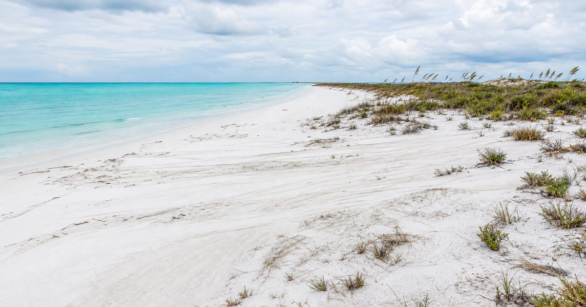
Dunes do much of the island’s protective work. Sea oats are especially important here. Their root systems help trap and stabilize loose sand, allowing dunes to build and recover. On a barrier coast, vegetation is not ornamental. It is structural.
That is one reason damaged dunes matter so much. Foot traffic, construction pressure, and storm erosion do not just alter the look of the beach. They weaken one of the island’s main defenses against wave action and overwash.
The wildlife story is just as tied to this narrow geography. Barrier islands support dozens of rare, threatened, or endangered plant and animal species. In nearby Choctawhatchee Bay lives the endangered Okaloosa darter, a reminder that the island cannot be understood apart from the surrounding watersheds and estuaries.
Then there are the turtles. Florida’s beaches account for about 70 percent of sea turtle nesting in the United States, and the nesting season runs from March through October. On Okaloosa Island, that turns a recreational shoreline into seasonal habitat. A chair left overnight, a deep hole in the sand, or stray gear can become an obstacle for nesting females or hatchlings trying to reach the Gulf. Rules that may seem minor on a beach vacation make more sense when the beach is understood as a nursery as well as a leisure space.
Older human history on a young coast
The resort shoreline is recent. Human presence in this region is not.
Archaeological evidence places habitation along the Gulf Coast back about 12,000 years, into the late Ice Age. Near the island, the clearest visible link to that deeper history is the Fort Walton Beach Heritage Park and Cultural Center, home to the Indian Temple Mound, a National Historic Landmark.
The mound was built around 800 AD and is one of the largest prehistoric earthworks on the Gulf Coast. It served ceremonial, political, and spiritual purposes and is estimated to have required about 200,000 basket loads of earth. It is also a sacred burial site.
Interpretation of the mound has changed over time. Earlier accounts linked it to the Fort Walton Culture, usually dated from 1200 to 1500 CE. Archaeologists now generally attribute its construction and use to the contemporaneous Pensacola Culture. That distinction matters. It shows how coastal history is refined through evidence rather than repeated by habit.
The name “Okaloosa” preserves an Indigenous trace in the modern landscape. It derives from a Choctaw word meaning “black water.” Even on a heavily developed shore, older meanings remain embedded in place names.
Tower Beach and the remaking of Santa Rosa Island
Long before the present strip of condos and beach access points, this section of Santa Rosa Island was promoted under another name: Tower Beach.
In the mid-1930s, developers established an amusement area here with a boardwalk, hotel, and attractions. It was an early effort to turn a barrier shore into a leisure landscape. That first version was short-lived. A fire destroyed much of Tower Beach on March 7, 1942, and wartime conditions halted rebuilding.
The episode is easy to treat as a local curiosity, but it reveals something larger about barrier coasts. Their history is shaped not only by storms and currents, but by abrupt human breaks: a fire, a war, a bridge, a land transfer, a zoning decision.
One such turning point came on July 8, 1950, when the federal government conveyed 875 acres of Santa Rosa Island to Okaloosa County for $4,000. U.S. Representative Bob Sikes helped secure the transfer. That deal laid the groundwork for the modern identity of Okaloosa Island.
The price now sounds startlingly low, but the transaction makes sense only if the beach itself is the real asset. Gulf frontage, access, and the prospect of development mattered more than the raw acreage. A shifting sandbar became county land, then a managed tourist coast.
Building on moving ground
Development did not stop the island from behaving like a barrier island. It simply placed roads, bridges, and buildings inside an active coastal system.
One feature distinguishes this shoreline from parts of Florida with taller resort skylines: height restrictions have kept much of the development to mid-rise scale rather than high-rise towers. That does not erase pressure from tourism in the Destin-Fort Walton Beach area, but it does shape how the built environment meets the beach.
The practical rules of the shore tell their own story. Beach flag warnings mark surf conditions and dangerous marine life. Glass is prohibited on the beach. County staff remove personal items left overnight. During sea turtle nesting season, people are asked to leave the sand clear and undisturbed. These are ordinary regulations, yet together they amount to a public admission that the island is not just real estate. It is habitat and unstable land at the same time.
Even the fixed landmarks underline the tension. Brooks Bridge links the island to Fort Walton Beach. Marler Bridge connects it toward Destin. The Okaloosa Island Fishing Pier, also called the Island Pier, extends into the Gulf as if to pin down a moving margin. It cannot. Nothing here is fully pinned down.
What Okaloosa Island reveals about Florida’s barrier coast
The island’s most obvious features are the ones postcards favor: white quartz sand, clear Gulf water, a bright edge between sea and sky. The more revealing features are quieter.
Look at the dune line and the sea oats holding it in place. Notice how narrow the land is between Gulf and bay. Notice how roads and condos sit on a strip that exists because sediment keeps arriving, shifting, and being rearranged. That is the real subject here.
Okaloosa Island works as a case study because so many layers remain visible at once. There is deep geological time in the Appalachian quartz. There is recent coastal time in the last 6,000 years of barrier-island formation. There is Indigenous history nearby in the temple mound. There is mid-century remaking in the 1950 transfer of county land. And there is the present tense of conservation, where sea turtle protection, habitat restoration, and watershed planning try to manage use without pretending the shoreline can be frozen.
The future pressure points are plain enough: coastal erosion, development, and rising water. Preservation on a barrier island does not mean fixing the coast in one ideal shape. It means accepting motion, protecting the habitats that make that motion survivable, and building with some humility on a shore that was never still.
FAQ
What is Okaloosa Island?
Okaloosa Island is a developed section of Santa Rosa Island on the Florida Panhandle, south of Fort Walton Beach. It is part of Florida’s Gulf barrier coast.
How was Okaloosa Island formed?
It formed from quartz sand eroded from the Appalachian Mountains, carried south by rivers, and reworked by waves, currents, storms, and sea-level change into a barrier island.
Why does Okaloosa Island keep changing shape?
Because barrier islands are mobile landforms. Longshore drift, tides, storms, wind, and erosion continually move sand along and across the shore.
What is the connection between Okaloosa Island and sea turtles?
The beaches are part of Florida’s major sea turtle nesting coast. During nesting season, obstacles left on the sand can interfere with nesting females and hatchlings.
What Native history is connected to the area?
The region has evidence of human habitation going back about 12,000 years. Nearby, the Indian Temple Mound at Fort Walton Beach is a major prehistoric earthwork built around 800 AD and now generally attributed to the Pensacola Culture.