A coral island no longer than a short coastal drive became the hinge of an oil state.
Kharg Island, also spelled Khark Island, sits in the northern Persian Gulf, roughly 25 to 28 kilometers off the Iranian coast and about 55 kilometers northwest of Bushehr. It covers only about 20 to 22 square kilometers. Its highest point, Kūh-e Dīdeh Bānī, rises to around 70 meters. Yet this small outcrop has handled the overwhelming share of Iran’s crude exports, often cited at up to 90 percent. Few places in the Gulf show so clearly how national power can depend on one stubborn piece of geology.
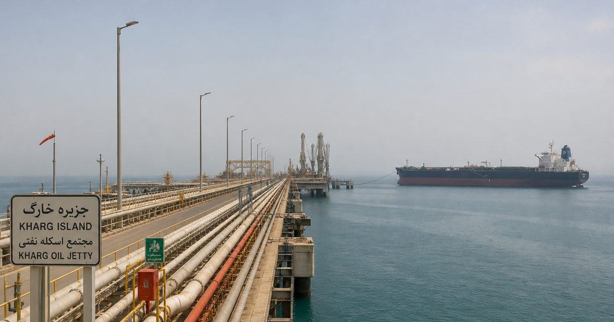
The reason starts in the water around it. Much of Iran’s Gulf coast is shallow. Kharg’s approaches are not. That difference sounds technical, but it explains almost everything that followed. Deep water let large tankers come alongside directly. Once pipelines, storage tanks and jetties were added, the island became the country’s main oil export terminal. Geography did not merely help Kharg. It chose it.
An island that mattered before oil
Kharg did not become strategic only when petroleum arrived. The island had been noticed for centuries because it sat in a useful position off the Iranian coast, close enough to the mainland to be supplied, far enough offshore to matter to traders and naval powers moving through the northern Gulf.
Evidence of settlement reaches back to the end of the second millennium BC, with traces linked in the article’s own chronology to the Elamite, Achaemenid and Sassanid periods. Later came outside empires. The Portuguese held the island between the 16th and 17th centuries. The Dutch followed in the 18th.
That older history matters because it keeps the modern story honest. Oil did not create Kharg’s importance from nothing. It sharpened an older pattern. A place once valued for trade routes and anchorage became valuable for tanker draft, pipeline links and export concentration.
Some of those earlier layers still survive in the landscape. The island contains the remains of a Dutch fort dated here to 1747, a Dutch Garden, a heritage cemetery with Zoroastrian burial sites and Christian graves, and tombs described as Sassanid. There is also an Achaemenid inscription carved into coral rock, given as 85 by 116 centimeters. Oil infrastructure now dominates the shoreline, but it sits on top of a much longer history of strategic use.
Why Kharg became Iran’s export outlet
The modern turn came in 1957, when Kharg was chosen as an oil terminal. The choice was practical. It lay within reach of producing regions such as Gachsaran. It could take large tankers. It offered relatively sheltered conditions. Above all, it solved a marine problem that the mainland coast could not solve as neatly: depth.
Construction began in 1958. Storage tanks, jetties, housing and an airfield followed. In August 1960, the deep-water terminal was officially commissioned and sent out its first major shipment.
That decision reorganized Iran’s oil map. Crude from inland fields and offshore discoveries could be gathered at one offshore node, stored at scale, and loaded straight onto large vessels. A mainland port might have had administrative advantages or a longer urban history. Kharg had the one thing the export system needed most: water deep enough for the biggest ships.
This is why the island eclipsed more familiar names. In the age of supertankers, prestige mattered less than draft depth. Kharg offered a rare fit between geology and industrial need.
Pipelines, berths and the making of an oil machine
During the 1960s, offshore fields including Faridun, Darius, Cyrus and Ardashir were discovered, and submarine pipelines linked them to the island. In the same decade, Kharg overtook Abadan as a major oil hub. By 1965, according to the article’s figures, a 106-mile, 42-inch pipeline ran from the Aghajari oil field to Ganaveh, with additional submarine loops connecting onward to the island.
Those details matter because they show that Kharg’s role was never just about one good harbor. It worked because several systems met there at once. Inland pipelines fed crude toward the coast. Offshore production came in by subsea line. Storage on the island buffered supply. Deep-water berths turned that stored crude into seaborne exports.
By the early 1970s, the island had become Iran’s largest oil-loading terminal. By 1975, it hosted three major terminals: Kharg Terminal, Sea Island Terminal and Darius Terminal, along with the Kharg Chemical Complex and a gas terminal. In 1977, exports from the island reached as high as 6 million barrels per day.
The scale remains startling when set against the island’s size. Kharg has been described as able to store around 30 million barrels and load up to 10 supertankers at once. Its loading capacity has been put at up to 7 million barrels per day under normal operation. Even if actual exports fluctuate, the built system is immense for a coral island only a few kilometers across.
This is the real oil geography of the Persian Gulf. Production starts in scattered fields, onshore and offshore. Export power depends on where those flows can be concentrated, stored and transferred to ships without delay. Kharg solved that problem better than any mainland alternative available to Iran.
Why deep water changed everything
A great deal of the island’s history can be reduced to one marine fact: deep water saves steps.
Where coasts are shallow, large tankers face limits. They may need offshore loading systems, lightering, dredging, or more complicated port design. All of that adds cost, time and vulnerability. Kharg’s natural approaches reduced those frictions. Very large crude carriers could dock directly.
That changed the economics of export. Bigger ships meant more oil moved per voyage. Faster loading meant less congestion. A terminal that could handle supertankers at scale became hard to replace once pipelines and storage were built around it.
So when people ask why a small coral island matters so much, the answer is not romance or symbolism. It is draft depth. Kharg became indispensable because it matched the physical requirements of modern oil shipping unusually well.
The danger built into efficiency
A system this efficient also carries a clear risk. When one place handles most of a country’s crude exports, efficiency and vulnerability become the same thing.
That logic became brutally clear after the Iranian Revolution of 1979, when Amoco’s property on the island was expropriated by the National Iranian Oil Company. Soon after came the Iran-Iraq War, fought from 1980 to 1988. Iraqi forces repeatedly targeted Kharg in an effort to damage Iran’s oil income. Between 1982 and 1986, heavy bombing put facilities out of commission. In 1984, Iraq widened the tanker war by attacking the terminal and tankers at Kharg.
The arithmetic was plain. If the vast majority of crude exports moved through one island, then striking that island meant more than damaging steel and concrete. It meant attacking state revenue, shipping confidence and wartime endurance.
Kharg’s facilities were heavily damaged, but they were also repaired and rebuilt again and again. That persistence says something important. The island was not simply valuable. It had no easy substitute. The same geography that made it efficient in peacetime made it a prime target in war.
Rebuilt and still central
After the war, reconstruction and expansion resumed in the early 1990s. Kharg returned to its role as the country’s main export outlet. The article notes that in 2009, Iran exported and swapped 950 million barrels of crude through the terminal. It also states that, as of 2015, facilities there were operated by the National Iranian Oil Company.
Recent figures in the source text point to exports typically hovering around 1.5 to 1.7 million barrels per day, with China described as the primary destination. Those numbers can shift with sanctions, shipping arrangements and production levels, but the larger point does not change: Kharg remains central to Iran’s seaborne crude trade.
Its strategic profile has sharpened rather than faded. The island is heavily protected, and access is tightly controlled. Storage capacity has required periodic rehabilitation and upgrading. Analysts often focus on the Strait of Hormuz when discussing Gulf chokepoints. Kharg suggests a different kind of bottleneck. Not every chokepoint is a narrow passage between coasts. Some are fixed pieces of infrastructure on a single exposed island.
The industrial island and the older one beneath it
Military restriction has given Kharg a reputation as a forbidden island, though that phrase can obscure more than it explains. The restrictions are not folklore. They follow from the island’s role as critical national infrastructure.
Behind the fences lies an industrial landscape of jetties, tank farms, pipelines and service facilities. Kharg Airport and the Jazireh-ye Khark Lighthouse belong to that logistical world. Yet the island is not only an oil platform. Shrines such as Mir Mohammad Shrine and Mir Aram Shrine remain part of its local topography. Tradition associates Mir Aram with a descendant of Noah; that should be read as local tradition, not established historical fact.
There is also a physical detail that complicates the usual image of a hard industrial outpost. Kharg has its own fresh-water supply, unusual for an island in the Persian Gulf. That has supported local settlement and wildlife, including gazelles. Even here, in one of the Gulf’s most strategic energy landscapes, the island remains a place with older human layers and its own ecology.
Jalal Al-e-Ahmad once called it the orphan pearl of the Persian Gulf. The phrase survives because it catches something real: isolation, exposure, and a strange doubleness. Ancient graves and coral rock sit within sight of loading arms and storage tanks.
What Kharg reveals about the Gulf
Kharg Island makes the oil geography of the Persian Gulf legible in miniature. Reserves underground are only part of the story. Export power depends on shipping depth, pipeline convergence, storage capacity and the willingness of a state to concentrate risk in one place.
Kharg answered those needs so well that it became indispensable. That is its strength and its weakness. The island is the backbone of Iran’s crude exports, and at the same time the point where those exports are most exposed. Its terminals and tank farms are not just industrial structures. They are the visible form of a national dependency built on one coral island with unusually useful water around it.
In that sense, Kharg is more than an oil terminal. It is a lesson in how geography can narrow a country’s options until strategy, infrastructure and geology all meet on a single shore.
FAQ
What is Kharg Island?
Kharg Island, also spelled Khark Island, is a small island in the northern Persian Gulf, off Iran’s coast in Bushehr Province. It is best known as Iran’s main oil export terminal.
Why is Kharg Island important?
Its deep-water access allows large tankers to load crude directly, which made it the key outlet for Iran’s oil exports. The island has handled up to 90 percent of those exports.
Why was Kharg chosen as an oil terminal?
The main reasons were practical: proximity to producing fields, room for storage and infrastructure, and rare deep-water approaches along a generally shallow coast.
Was Kharg Island attacked during the Iran-Iraq War?
Yes. Iraqi forces repeatedly struck the island and its shipping during the war, especially between 1982 and 1986, because disrupting Kharg meant disrupting Iran’s oil revenue.
Can tourists visit Kharg Island?
Access is heavily restricted because of the island’s military and energy importance. Civilian visits require special permission.