In 1999, workers moved Cape Hatteras Lighthouse about 880 meters inland. The brick tower survived the journey intact. Staying where it stood had become the greater risk: the Atlantic had eaten away much of the beach that once separated it from the water.
The move solved a problem for one building. It could not solve the problem of keeping an island in place.
Hatteras Island extends roughly 80 kilometers along North Carolina’s Outer Banks, between the Atlantic Ocean and the waters of Pamlico Sound. Much of its surface lies only a few meters above sea level. Its beaches and dunes belong to a barrier built largely of loose sediment, rather than a rocky coastline that resists the sea.
Here, erosion does not always mean that land simply disappears. Sometimes the sand travels along the shore. Sometimes it settles offshore. During storms, some crosses the island and comes to rest on the sound side. Understanding those different journeys changes how this narrow strip of land looks.
An island assembled by rising seas
The coast beneath the Outer Banks lies along a passive continental margin, far from an active tectonic plate boundary. Volcanic eruptions did not raise Hatteras Island. Moving sediment built it as the shoreline changed position.
During the last glacial period, global sea level stood more than 120 meters below its present level. The Atlantic shoreline lay well east of today’s beaches. As ice sheets melted, rising water flooded the coastal plain, and waves and currents reworked its sediment.
The modern barrier system developed over the following millennia. Estimates commonly place the formation of much of the present Outer Banks around 4,000 to 5,000 years ago, although its sections have different histories. Older deposits beneath and offshore of the islands also influence their shape.
Exactly how the first barriers took form remains a subject of geological research. Offshore sandbars, former shoreline features and the flooding of low coastal terrain all figure in explanations of barrier development. A simple story in which ancient dunes became submerged and then reappeared as islands leaves too much out.
What matters for Hatteras is that its present shoreline is a temporary arrangement of sediment. The island has persisted through change, not by remaining fixed.
Where the sand goes
An ocean beach can look almost unchanged between visits while substantial quantities of sand pass through it.
Waves arriving at an angle push sediment along the shoreline. This longshore transport feeds some stretches of beach and removes material from others. Its direction and strength vary with weather and wave conditions; a long-term net movement conceals many shorter reversals.
Sand also moves across the shore. Storm waves can strip a beach and deposit sediment in offshore bars. Under gentler conditions, waves may return some of that material. A narrower beach after a storm does not, by itself, reveal how much sand has permanently left the local system.
Above the ordinary reach of waves, wind takes over. It lifts dry grains and carries them inland until vegetation, damp ground or another obstacle slows them. Dunes grow where enough of that sand accumulates.
These processes connect parts of the landscape that appear separate. A dune is a sediment store supplied by the beach. An offshore bar may contain sand that stood above water weeks earlier. The sound-side margin can receive material washed across the island.
The crucial question is therefore more precise than “Is the beach eroding?” It is: where has the sediment gone, and can it still contribute to the barrier?
When water crosses the island
During a hurricane or nor’easter, elevated water levels allow waves to reach beyond their usual limits. Water may overtop a dune or cross a low stretch of the island, carrying sand with it.
As that flow spreads and slows, it drops sediment. The resulting washover deposits can extend across the barrier toward Pamlico Sound.
For a house or road in their path, these flows are destructive. Salt water floods buildings, sand buries pavement, and currents can scour away the ground beneath structures. The geological role of overwash does not diminish those consequences.
Yet the same event can help the island adjust to a retreating shoreline. Sediment lost from the ocean side becomes an addition farther landward. Repeated over long periods, this transfer supports a process often called barrier rollover.
That term can suggest a tidier movement than actually occurs. Hatteras does not advance toward the mainland as a single, even strip. Different reaches respond differently according to their width, elevation, sediment supply and exposure. Some accumulate broad sheets of sand; others lose material without receiving enough to compensate.
Washover flats make one part of this movement visible. Their low, open surfaces record water passing across ground that a conventional map presents as a firm boundary between ocean and sound.
The night the coastline opened
A hurricane in 1846 opened Oregon Inlet and Hatteras Inlet, establishing passages that still define the ends of Hatteras Island.
An inlet changes more than the outline of a beach. It creates a route through which tides exchange water between the Atlantic and the sounds. Those currents scour channels, move shoals and redistribute sediment around the opening.
The resulting geography never quite settles. Channels shift. Sandbanks emerge or erode. Inlets can migrate as one bank retreats and sediment builds against the other, though their rates of movement vary over time.
Oregon Inlet illustrates the practical consequences. Shoaling creates persistent difficulties for navigation, requiring repeated surveying and dredging. A channel deep enough for passage is a maintained condition, not a permanent property of the inlet.
On the sound side, incoming tidal currents deposit sand in shoals known as flood-tide deltas. Over long periods, these deposits can become part of the sediment foundation over which a barrier migrates.
Hurricane Isabel reopened the question of where Hatteras Island began and ended in 2003. Storm surge breached the island near Hatteras village, severing the road connection. The temporary opening was subsequently filled, and the road was rebuilt.
The contrast with 1846 is instructive. Storms created new waterways in each case, but human decisions helped determine which openings remained on the map.
Dunes built to hold a line
A continuous dune ridge can appear to be the island’s natural defensive wall. On Hatteras, that appearance sometimes conceals a history of deliberate construction.
During the 1930s, Civilian Conservation Corps crews helped establish artificial dunes along the Outer Banks. Sand fencing trapped windblown grains, and planting encouraged the ridges to grow and persist.
The aim was stabilization. Higher dunes reduced the frequency with which ocean water crossed the barrier, helping protect land and infrastructure behind them.
But reducing overwash also interrupts a route by which sediment reaches the island’s interior and sound-side margin. A measure that protects a road during one storm can alter the barrier’s longer-term adjustment to a moving shoreline.
That does not make every dune an obstacle or every overwash event beneficial. Natural dunes belong to the system too, and storms can remove sediment from places that cannot readily recover it. The effects depend on local conditions.
Beach nourishment introduces another intervention. Pumping or placing sand onto an eroding shore can widen the beach and provide material for waves to redistribute. It can reduce immediate exposure without making the shoreline permanent.
The underlying conflict is between different timescales. Residents need reliable access and protection now. The island’s survival over centuries may depend on movements that damage those same roads and properties.
A road across shifting ground
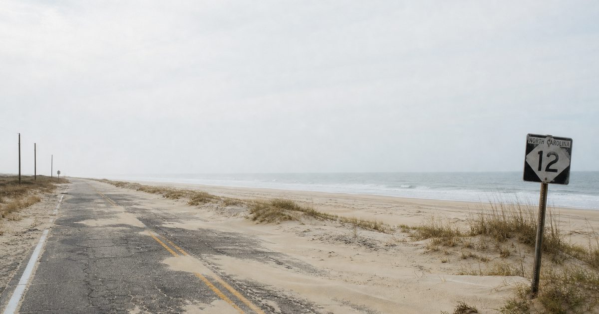
North Carolina Highway 12 gives the island’s geology an everyday consequence. When water breaches the barrier or sand covers the pavement, communities can lose their road connection.
Bridges, repairs and changes in alignment reflect attempts to maintain access without relying entirely on the same vulnerable strip of ground. Each response addresses a particular location. None stops the larger movement of sediment.
At Rodanthe, severe erosion has exposed the consequences for oceanfront homes. Buildings constructed behind a beach can eventually stand at the water’s edge as the shoreline retreats. Some have collapsed into the surf, releasing debris that creates hazards beyond the property itself.
Retreat rates vary greatly along Hatteras Island and across different measurement periods. A figure measured at one erosion hotspot should not become a prediction for every village, much less a countdown for the whole island.
The lighthouse offers a more concrete measure of the problem. Its relocation preserved a historic structure by changing its position. That option is harder to apply to an inhabited island with roads, utilities, property boundaries and generations of attachment to particular places.
What determines whether a barrier persists?
Sea-level rise changes the conditions under which every movement of sand takes place. Water reaches farther across low ground, while the barrier must accumulate or redistribute enough sediment to maintain land above it.
The rate of rise matters, but so do sediment supply, storms, underlying geology and the space available for landward movement. These factors interact. There is no single threshold that predicts the fate of every stretch of Hatteras.
Researchers examine several possible responses: continued landward migration, narrowing, fragmentation and, under some conditions, loss of substantial sections of the barrier. These are conditional outcomes, not a settled timetable.
Forcing the ocean-facing edge to remain in one place does not necessarily preserve the whole island. Equally, allowing movement offers no guarantee that every part will persist.
On a washover flat, the scale of the process is easier to see. Sand lies across the ground in a shallow fan, beyond the beach where it began. The next storm may spread it farther, cut through it or carry some away. For the moment, it is part of Hatteras Island.
FAQ
Why is Hatteras Island eroding?
Waves, currents and storms remove and redistribute its sand. Sea-level rise adds pressure, while local sediment supply and coastal engineering influence how individual stretches respond.
Is Hatteras Island moving inland?
Parts of the barrier migrate landward as sediment accumulates behind the retreating ocean shore. This movement is uneven; erosion alone does not guarantee successful migration.
What is overwash on Hatteras Island?
Overwash occurs when elevated water and waves cross dunes or low ground, carrying sand inland. It can damage infrastructure while supplying sediment to the barrier’s landward side.
Did a hurricane create Hatteras Inlet?
Yes. A hurricane opened Hatteras Inlet and Oregon Inlet in 1846. Their channels and surrounding shoals have continued to change since then.
Why was Cape Hatteras Lighthouse moved?
Shoreline erosion threatened the tower at its original site. In 1999, workers relocated it about 880 meters inland to reduce its immediate exposure to the ocean.