A low island, a sheer drop into deep water, and a name first given for turtles: Grand Cayman has always been explained by what happens just offshore. The reefs around it fed families and ripped open hulls. They turned local men into turtlers and seafarers, then forced the island to confront what overuse had done. If you want to understand Grand Cayman, start in the waterline where coral, wreckage, and turtle tracks meet.
Grand Cayman is the largest of the Cayman Islands, a British Overseas Territory in the western Caribbean. George Town sits on its limestone edge. The island itself is modest in scale, about 35 kilometers long and only around 18 meters at its highest point. Yet the sea around it is anything but modest. Here, a narrow shelf gives way to reefs and then to very deep water. That contrast shaped work, diet, danger, memory, and eventually conservation law.
A limestone rim above deep water
From shore, Grand Cayman can seem almost flat enough to skim. The drama lies below the horizon line.
The Cayman Islands rise from the Cayman Ridge, an underwater mountain chain stretching between southeastern Cuba and Belize. South of that ridge lies the Cayman Trough, a broad, very deep marine basin more than 4.8 kilometers at its deepest points. Near the surface, though, Grand Cayman is built largely from marine carbonates laid down over millions of years by corals, algae, and other shell-forming organisms. The island’s limestone is, in that sense, old reef made land.
That geology matters because it produced several kinds of reef in a small area. There are fringing reefs close to shore, deeper reef structures farther out, and the steep wall for which the islands are famous. For marine life, this creates a rich set of habitats. For ships under sail, it created a problem. A low island offers little warning. Reefs can lie just beneath clear water. A captain who misread wind, current, or depth could move from open passage to splintered hull in minutes.
So the same coral formations that supported fish and turtles also made Grand Cayman a place where local knowledge carried real value. People who knew the channels, the weather, and the reef line possessed more than practical skill. They held the difference between safe arrival and disaster.
When turtles named the islands
The first European name attached to these islands came from an animal. In 1503, Christopher Columbus recorded them as Las Tortugas because of the abundance of sea turtles, especially green turtles, Chelonia mydas.
That was more than a passing note in a logbook. In the age of sail, turtles were a useful form of food because they could be kept alive on board. For ships crossing the Caribbean, the islands became a provisioning point. A live turtle was not preserved meat or dried ration. It was fresh protein that traveled.
On Grand Cayman, that abundance became a way of life. Turtling supported local subsistence and trade, and it tied Caymanians to a wider maritime world that reached beyond the island’s own waters. The sea was not a scenic backdrop to settlement. It organized settlement. Men went to sea for turtle, fish, salvage, and merchant work. Skills moved through families. So did stories, routes, and risks.
The turtle trade also left cultural traces that outlasted its economic peak. Turtle stew remained part of Caymanian foodways, especially on ceremonial or festive tables. That continuity matters. It helps explain why later debates over protection, farming, and consumption were never only about wildlife policy. They also touched memory, identity, and the authority of custom.
The sea gives, then empties
Abundance on Caribbean coasts often looked endless until it did not. Grand Cayman followed that pattern.
By the late eighteenth and nineteenth centuries, local turtle stocks had been heavily depleted. The response was not immediate restraint. Caymanian turtlers ranged farther afield, working waters off Cuba and the Central American coast, including Nicaragua’s Mosquito Coast. That expansion kept the trade alive for a time, but it also showed that nearby grounds no longer yielded what they once had.
By the early twentieth century, local turtling had ceased to be a reliable basis for income. This was a turning point in the island’s relationship with the sea. A resource that had helped name the islands and sustain generations had been driven down by sustained harvest.
The modern answer took a form that remains unusual and contested. In 1964, Mariculture Ltd was established on Grand Cayman to breed green sea turtles commercially. It later became known as the Cayman Turtle Farm and is now the Cayman Turtle Centre. In 1978, the operation became self-sufficient in eggs from its captive breeding herd. The centre has also been credited as the first enterprise to domesticate the green sea turtle and the first to breed the endangered Kemp’s ridley turtle in captivity. Its record in captive breeding is central to any account of turtle conservation Grand Cayman now tells about itself.
That does not make the institution simple. Debate has long surrounded the balance between conservation aims and commercial activity, including the sale of turtle meat. Any honest account has to leave room for that tension. The centre belongs to the history of recovery, but also to the history of argument over what recovery should look like.
From harvest to protection
Law arrived after depletion, not before it. In 1986, the Cayman Islands enacted a complete ban on harvesting wild sea turtles. In 1988, turtle hunting was formally banned, with limited exceptions for licensed heritage hunting that have been rarely used in recent years.
Even then, the damage was stark. In 1999, Grand Cayman recorded zero green sea turtle nests.
The rebound that followed is one of the island’s most striking environmental stories. It was not smooth. In 2001, Hurricane Michelle inundated the Cayman Turtle Centre and washed many turtles out to sea, with the loss of 75 percent of the breeding turtles. Yet the wider recovery effort continued. A 2011 genetic study found that 90 percent of nesting female green turtles on Grand Cayman were genetically related to turtles released from the centre. By 2019, green sea turtle nests across the three Cayman Islands had risen to 675.
Those figures do not erase the earlier collapse. They make it legible. The island moved from extraction to near-absence, then into a managed recovery shaped by law, captive breeding, release programs, and protection of nesting beaches. The green turtle is still part of Caymanian culture, but no longer in the same role. It is now also a marker of restraint, controversy, and repair.
For anyone searching why there are so many turtles in the Cayman Islands, that is the real answer: there were once far more, then far fewer, and the present landscape is the result of depletion followed by deliberate intervention.
Reefs that fed people and wrecked ships
Turtles explain the islands’ first colonial name. Reefs explain much of their daily history.
More than 325 ships are said to have sunk around the Cayman Islands. Whether every wreck can be counted with confidence is less important than the pattern itself. On a low island ringed by coral, wrecks were not rare anomalies. They were built into the maritime life of the place.
The best-known example is the Wreck of the Ten Sail. On 8 February 1794, a convoy of ten vessels, including HMS Convert, struck the reef off East End. Eight people died, but local residents rescued many of the crews and passengers. The event survives in Caymanian folklore as more than an accident. It has become a story about seamanship, mutual aid, and the local ethic often described as “Caymankind.”
That phrase can slide into slogan if used carelessly. The harder fact beneath it is that reef communities often had to respond quickly and collectively to disaster. Rescue demanded boats, swimmers, judgment, and nerve. In that sense, the reef was not simply a hazard. It was a recurring test of local competence.
Later wrecks show that this was not only an age-of-sail story. In 1944, the Cali, a steel-hulled freighter carrying 30,000 bags of rice, sank in George Town harbour after water entered the cargo hold, the rice expanded, and the hull split. In 1981, the Gamma, another freighter carrying rice, sank off Seven Mile Beach during a storm. These losses belong to a modern commercial era, but they were shaped by the same old combination of weather, cargo, and underwater topography.
So when people ask what the Cayman Islands are known for beneath the postcard surface, part of the answer lies here: coral reefs that sustained marine life and repeatedly interrupted maritime trade.
Wrecks become reef again
Over time, Grand Cayman’s relationship with wrecks changed. A ship on the reef was once a calamity, then a salvage opportunity, then eventually something else: habitat, memory, and dive site.
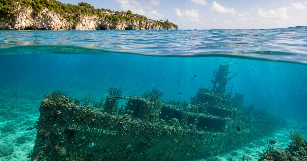
That shift is clearest in the age of artificial reefs. In 2011, the USS Kittiwake, a 76-meter former submarine rescue vessel, was intentionally sunk off Seven Mile Beach. It was placed there to create an artificial reef and a site for divers and snorkelers. The logic was modern, but the underlying relationship was old. Metal on the seabed becomes structure. Structure gathers life. People return to it, though for different reasons than before.
The same can be said, in a looser way, of older wrecks. The Gamma near shore and the remains of the Cali in George Town harbour are not just curiosities. They show how quickly working vessels can pass into the ecology and folklore of a place. A wreck begins as an event, then becomes a landmark, then a habitat.
This is one reason Grand Cayman shipwrecks occupy such a large place in the island’s imagination. They sit at the junction of danger, labour, and marine life. Coral grows over steel and timber. Fish move through cargo holds and broken frames. Human error, weather, and geology settle into one scene.
The protected sea
Protection now forms part of the same story, not a separate chapter tacked on at the end. Marine rules around Grand Cayman reflect a long lesson learned the hard way: a reef can be productive and fragile at once.
Marine Protected Areas now cover a large share of the islands’ coastal waters. In Marine Park Zones, taking marine life, alive or dead, is prohibited. Replenishment Zones restrict extraction more selectively, including bans on taking conch or lobster, while allowing line fishing in deeper water under specified conditions. These are not abstract lines on a policy map. They shape how local people fish, where boats anchor, and how visitors move through the water.
That framework matters because the island’s marine identity no longer rests on extraction alone. It rests on management, recovery, and limits. The same waters that once supplied turtle meat and salvage now support research, education, diving, and protected habitat. Grand Cayman coral reefs are still biologically rich, but they are also under pressure from disease, warming seas, and the cumulative effects of human use. Protection is not proof of health. It is evidence that health cannot be assumed.
The turtle story makes that plainest. The reef story confirms it. Grand Cayman did not become itself despite reefs, wrecks, and turtles. It became itself through repeated encounters with all three, first as resource and hazard, later as inheritance that required rules.
FAQ
Why were the Cayman Islands first called Las Tortugas?
Because Christopher Columbus recorded the islands in 1503 for their abundance of sea turtles, especially green turtles.
What is the Wreck of the Ten Sail?
It was the wreck of a convoy of ten ships off East End on 8 February 1794. Local residents rescued many survivors, and the event became a major story in Caymanian memory.
Why are turtles important in Grand Cayman?
They shaped the island’s early economy, diet, and maritime culture. Later, after severe depletion, they became central to conservation law and captive-breeding efforts.
Can you still eat turtle in the Cayman Islands?
Wild turtle harvest is largely banned. Turtle meat has been supplied through the Cayman Turtle Centre, which remains part of a wider debate about culture, commerce, and conservation.
What is the USS Kittiwake?
The USS Kittiwake is a former submarine rescue vessel intentionally sunk off Seven Mile Beach in 2011 to create an artificial reef and dive site.