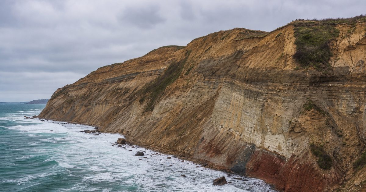
A staircase of 141 steps drops through scrub and wind to the foot of the Mohegan Bluffs. Halfway down, the island stops looking pastoral and starts looking torn open. Clay slumps out of the cliff. Gravel sits in rough bands. Sand appears where it should not, then vanishes again into a darker seam. What stands above as a green Atlantic island reveals itself here as a pile of glacial leftovers, still being sorted by water.
That exposed edge is one of the clearest ways to understand Block Island. Officially the Town of New Shoreham, it lies about 14 kilometers south of mainland Rhode Island and 23 kilometers east of Montauk Point. It is modest in size, roughly 10 kilometers long and 5.5 kilometers wide, with Beacon Hill rising to 64.3 meters. Yet its southern coast tells a story on a much larger scale. This is part of the same glacial family as Cape Cod, Martha’s Vineyard, and Nantucket, but on Block Island the evidence is unusually legible. The bluffs show how the island was made. Their steady retreat shows how it is being remade.
An island left by ice
Block Island is a moraine: land built from debris carried, dumped, and rearranged by glacier ice and meltwater near the end of the last ice age. That much is straightforward. The details are not.
The island’s geology belongs to the Wisconsinan glaciation, and researchers have long divided its deposits into older and younger phases, often labeled Early Wisconsinan or Altonian, and Late Wisconsinan or Woodfordian. In plain terms, the island was not formed in one simple push. Evidence points to at least two glacial episodes and to material arriving from more than one ice lobe.
One of those was the Narragansett Lobe, associated with the older deposits. A younger lobe later approached from a more north-northwesterly direction. Together they left the island with two main morainal masses and a more complicated zone between them. That matters because Block Island does not behave like a neat ridge of sand and gravel. It is a layered body with different sediments, different strengths, and different ways of failing when water gets into it.
Older material lies beneath that glacial framework. Under the Wisconsinan moraine are remnants linked to an Illinoian-age moraine, dating roughly to 200,000 to 140,000 years ago. Beneath that sit Cretaceous strata, with as much as 41 meters of those older sediments underlying the island. Some of that Cretaceous material did not stay buried. Later glacial action tore it up and redeposited it into the younger moraines. So the island is not just glacial. It is recycled.
Seen across the surface, that history explains the island’s uneven form. Two rocky glacial sections are linked by sandy barrier spits. Moraines, meltwater channels, and drumlins shape the interior. In the central part of the island, drumlins trending north-northwest to south-southeast nearly enclose an embayment. Rodman’s Hollow, often noticed for its depth and shelter, is part of the same inheritance: a depression left by ice and later modified by erosion and drainage.
Geologists have also grown more cautious about drawing exact one-to-one lines between Block Island’s moraines and those on Long Island or Martha’s Vineyard. The broad kinship is real. The old habit of matching every ridge too neatly across the region is less persuasive. Block Island belongs to the Outer Lands, but it has its own structure.
What the Mohegan Bluffs reveal
On the south shore, all of that buried complexity meets the Atlantic. The Mohegan Bluffs rise about 46 to 61 meters above the water, a long face of clay-rich glacial deposits cut into by waves, rain, groundwater, and gravity. They are often described for their height, but their real force lies in what they expose. These are not cliffs of solid bedrock. They are unconsolidated glacial sediments, stacked and disturbed, vulnerable to seepage and collapse.
That distinction explains the look of the place. A bedrock cliff tends to break in blocks. The bluffs on Block Island slump, shear, and peel away. Fresh scars appear pale against older weathered faces. After rain, water seeps through the sediments and weakens them from behind. Even on a calm day, the cliff can feel unstable because the sea is only part of the process. Freshwater moving through the bluff is another.
Coastal erosion here is not incidental damage to a scenic edge. It is one of the mechanisms that keeps the shoreline system going. As the bluffs retreat, they release sand and gravel. That sediment helps feed beaches and dunes elsewhere along the coast. One part of the island loses ground so another can hold, at least for a while. The destruction is real, but so is the replenishment.
That is why the cliffs matter beyond their appearance. They are not simply a dramatic lookout or a famous stairway. They are the active margin of the island’s geology. If you want to understand Block Island erosion, this is the place to start.
Retreat is part of the system
The island’s coast has long been in motion, and the southern bluffs make that motion visible. Some stretches have lost land quickly enough to force hard decisions. Reports of severe retreat vary by location and time span, but the broader point is clear: this shoreline does not stay put.
The Southeast Light became the island’s clearest measure of that fact. Built near the bluff edge, the brick lighthouse eventually stood too close to a retreating coast to be left in place. In 1993, it was moved 61 meters inland. The move was an engineering project, but it was also an admission. The bluff line was not a backdrop. It was an active boundary, and the building had to yield.
That relocation is often told as a preservation story. It is also a geological one. The same erosion that threatened the lighthouse is the process that keeps exposing glacial layers and supplying sediment to the shore below. Saving the structure did not stop the bluff from changing. It only bought distance.
Current planning on the island reflects that reality. Researchers, including teams from the University of Rhode Island and partner organizations, study coastal change, erosion, and sea level rise to inform adaptation. Proposed responses include dune restoration, beach nourishment, and other nature-based measures. Some dramatic scenarios about future shoreline change circulate widely, including claims that the island could split in two under relatively modest sea-level rise. Those projections remain debated, especially where barrier beaches and sediment movement are involved. The coast is dynamic, but simple maps of future loss can flatten a far more complicated process.
Before the lighthouse, Manisses
Long before the bluffs became a geological landmark, this was Indigenous land. The island was known as Manisses, a name usually translated as “Manitou’s Little Island” or “Island of the Little God.” The first inhabitants were Native people connected in the historical record to the Narragansett, Niantic, and Manissean communities, with evidence of human presence on the island going back thousands of years.
That older history matters because the landforms now read by visitors as scenery were once part of a lived landscape. Ponds in glacial hollows, protected inlets, exposed coasts, and arable patches shaped daily life. People here fished, gathered shellfish, hunted deer, and grew corn, beans, and squash. The island’s glacial topography was not an abstract inheritance. It was home ground.
The Mohegan Bluffs also carry a well-known local tradition about a battle between Niantic and Mohegan groups in the mid-16th century, ending with Mohegans driven from the cliffs. It is part of the island’s remembered past, but it should be read as tradition rather than settled fact. The story persists because the landform gives it force. Standing at the edge, it is easy to see why memory attached itself here.
Dangerous water below a changing coast
The same coast that reveals the island’s glacial structure also helps explain its maritime history. Block Island sits near busy waters, and its shoals, weather, fog, and exposed approaches have produced a long record of wrecks. The cliffs and the shipwrecks belong to the same story: a hard-to-read coast at the meeting point of land, current, and traffic.
One of the most famous losses entered folklore almost at once. In 1738, the Princess Augusta, later widely remembered in local legend as the Palatine, was wrecked off Sandy Point. The historical wreck is one thing; the “Palatine Light” is another. That glowing ghost ship belongs to folklore, not documented maritime fact, but it has become inseparable from Block Island’s coastal imagination.
Another tradition places Captain Kidd in these waters and supposes that he hid treasure on the island. Again, this is legend, not established history. But it is the kind of legend this coastline invites. Fog, wreckage, eroding banks, and shifting light encourage stories that refuse to stay on shore.
The documented record continues through the 19th and 20th centuries. The schooner Warrior was wrecked off Sandy Point in 1831. In 1846, a vessel carrying hard coal grounded in Cow Cove, and its cargo reportedly helped replace peat as a local fuel source.
Then came the disaster that fixed Block Island in rescue history. In 1907, the steamer Larchmont collided with the three-masted schooner Harry Knowlton. Island fishermen rescued survivors in brutal winter conditions and later received Carnegie medals for their efforts. In a coastal history full of losses, this is one of the clearest episodes of skill and courage.
The wreck most visible in the modern imagination is the tanker Lightburne. In 1939, the 127-meter Texaco vessel ran aground below the Southeast Light carrying 72,000 barrels of kerosene and gasoline. The crew was rescued. The ship was later dynamited to reduce the navigational hazard, and its remains now lie in about 9.1 meters of water. Today the site is known to divers, but its first meaning was simpler: another large vessel undone by a difficult coast.
A later collision added to that record. In 1945, the Annapolis, a 70-meter coal barge, sank after colliding with a U.S. submarine near the island.
These wrecks are sometimes told as a separate maritime chapter. They make more sense when placed beside the geology. A glacial island with retreating bluffs, shifting sediment, barrier shores, and exposed approaches does not end at the waterline. Its hazards continue offshore.
The coast as archive
For such a small island, Block Island shows an unusual amount of its own making. The Mohegan Bluffs remain the sharpest expression of that fact. They expose glacial till and redeposited sediments in a raw cross-section. They show how freshwater and wave action work together. They explain why a lighthouse had to move. They even help explain why the waters below carry so many stories of wreck and rescue.
This is what makes the south shore more than scenery. The bluffs are the island’s archive, but not a quiet one. The record is unstable. It slumps, erodes, feeds beaches, and threatens whatever sits too close to the edge. On Block Island, geology is not buried in a museum case or hidden under forest. It is out in the weather, changing as you look at it.
FAQ
How was Block Island formed?
Block Island was formed by glacial deposition. Receding ice left moraines of clay, sand, gravel, and older reworked sediments that still shape the island today.
What are the Mohegan Bluffs made of?
The Mohegan Bluffs are made of unconsolidated glacial deposits, including clay-rich till, sand, and gravel, exposed in steep coastal cliffs.
Why was the Southeast Light moved?
The Southeast Light was moved 61 meters inland in 1993 because coastal erosion had brought the bluff edge dangerously close to the lighthouse.
Are there famous shipwrecks off Block Island?
Yes. Well-known wrecks include the Princess Augusta of 1738, remembered in folklore as the Palatine, and the tanker Lightburne, which grounded in 1939.
Is the Palatine Light real?
The wreck behind the story is real. The “Palatine Light” is a local ghost-ship legend associated with the loss of the Princess Augusta, not a documented phenomenon.